Trail updates: Melton Ravine, 121 St, Saskatchewan Drive, High Level Bridge

Melton Ravine

The City of Edmonton owns and maintains many outfalls along the North Saskatchewan River. These outfalls serve as stormwater control facilities for residential and industrial developments. Outfall #24 has been identified by the City of Edmonton to be in deteriorating condition and requires rehabilitation in order to ensure the existing infrastructure continues to operate in a safe manner. Outfall #24 is located on the west bank of the North Saskatchewan River, east of Valleyview Crescent and 136 Street and approximately 250 m northwest and downstream of the footbridge which connects Buena Vista Park to William Hawrelak Park.

Construction began in early November and is expected to be completed by late December 2015.

Pedestrian and cyclist access is not permitted in construction areas, but a narrow footpath is accessible along the south side of the Melton Ravine access route, maintaining limited access from Valleyview Crescent to the Hawrelak Park pedestrian bridge. Due to the narrowness of the path (less than 1m at times), dismounting is recommended.

Project details can be found on the City's website.

121 St

Two projects are currently impacting the 121 St bike route.

ATCO has been directional drilling to work on underground pipe along the 121 St shared-use path, with the project potentially extending as far south as 102 Avenue, including opening pits on 121 St (covered with steel plates). The work is expected to be done by the end of December 2015.

As part of offsite improvements for the Brewery District, work is also happening on 121 St between 105 Ave and 106 Ave, eliminating direct access. Cyclists and detour using 123 St. Work is planned to be completed by the end of this week.

Saskatchewan Drive

The shared-use path along Saskatchewan Drive at 105 St and 106 St is now open, freshly paved and widened.

High Level Bridge

The west shared-use path is open and will remain open until 8am on Monday, November 30.

The east shared-use path will close at 8am on Monday, November 16. It will remain closed until 4pm on Friday, December 4.

November 24 update: The east shared-used path will remain closed until December 22, reopening on December 23. The west path will remain open until January 3, then close from January 4th until the first week of February.

For more information, visit the City of Edmonton's Safety Rails project website.

More trail closure information can be found on the City of Edmonton's Trail/Park Cautions & Closures website. Road closures are listed on the City's Current Traffic Disruptions page.

Free tickets to Rachmaninoff's 2nd Piano Concerto with the Edmonton Symphony Orchestra

Winspear.jpg

Come in out of the cold this weekend and join us at the Winspear Centre for the famed Rachmaninoff Piano Concerto no. 2. This tremendous concerto premiered in Moscow on October 14, 1901. It became the most popular piano concerto of the 20th century, and its popularity has not diminished into this century either. Awash with strong melodies, several pop songs have been drawn from its rich soil. Other pieces to be performed this weekend include:

  • Ralph Vaughan Williams, Norfolk Rhapsody No. 1
  • Jean Sibelius, Lemminkainen Suite Op. 22

EBC has 5 free pairs of tickets for each evening to give to current EBC members. Regular tickets range in price from $24-79.

Many thanks to the ESO for providing these complimentary tickets to our members.

Friday, Nov. 20 7:30 pm On Friday only: Join the ESO for Afterthoughts, a casual post-concert conversation in the main lobby with our guest artists, hosted by D.T. Baker.

Saturday, Nov. 21 8:00 pm On Saturday only: Arrive early for Symphony Preludes, an in-depth presentation about musical works to help make the most of your concert experience, starting at 6:45 pm in Enmax Hall (Main Performance Chamber), free to all ticket holders.

Both performances are at the Winspear Centre (#4 Sir Winston Churchill Square, Corner of 99th Street and 102 Avenue).

Conducting phenom Alexander Prior has a special affinity for music from northern lands. He leads the ESO in music by the Finn Sibelius, the Englishman Ralph Vaughan Williams, and the Russian Rachmaninoff, the latter featuring Bernd Glemser making his ESO debut with the always popular Second Piano Concerto.

The Edmonton Bicycle Commuters Society has 5 free pairs of tickets to give away to this event to our members. To reserve your free pair of tickets, please fill out the form below.

Safety Measures at 99 Street, Scona Road, and Saskatchewan Drive

99SCONASASKDR_STREETVIEW.jpg

As a result of two independent traffic safety assessments, the City of Edmonton has recommended specific countermeasures along the Scona Road and 99 Street corridors as well as the intersection of Scona Road, 99 Street and Saskatchewan Drive. The city will host an open house meeting in January 2016 to present these measures to the public. 99SCONASASKDR_MAP

EBC is seeking input from the public on the challenges they face walking or cycling along 99 Street or Scona Road, and also where they intersect at Saskatchewan Drive.

We would like to hear from you before Sunday, November 22, 2015 so we can communicate your comments and concerns to the City of Edmonton in advance of the January open house.

Please complete this form to provide your input. The exact date and time of the open house will be made available soon and will be posted on our blog and events calaendar when it is.

99SCONASASKDR_STREETVIEW

Design Thinking and the City: Dignity Lies in the Details

winter_season_in_canada_11508882835.jpg

This is a guest post written by Robin Mazumder and originally posted on his excellent blog.

Last winter I had an experience that changed the way I saw urban design.

It was mid-February. It was one of those days that was so cold that the city seemed to be blanketed in a mist of ice. Certainly not a day one wanted to spend outside for too long.

I was on my bike, waiting to cross an intersection in downtown Edmonton. That winter was the first that I had decided to participate in winter cycling. I bought an old beater mountain bike and outfit it with some studded tires. It was the best decision I had made in a long time. Winter cycling is a lot of fun.

So, there I was waiting at the light, which seemed to be red for an eternity. To my right, there was a pedestrian waiting for the light to change as well. He wasn’t wearing a winter jacket, or gloves for that matter. He appeared to have mobility issues. He was pushing a shopping cart which I later realized was doubling as a makeshift walker. We looked at each other and had a moment of shared frustration as we were patiently waiting for the crosswalk man to appear. The delayed crossing allowed us time to share some small talk, so I decided to jump off my bike and stand with my new acquaintance, who I’ll call John.

The time finally came that we were given permission to cross. I walked with John as he slowly moved one foot behind the other whilst pushing his cart over the ruts in the snowpack made by vehicles. It was a visibly taxing process for him, and difficult for me to watch. The occupational therapist in me grew agitated with the lack of accessibility this man experienced. We neared the midway point in the intersection when the menacing stop hand began to flash, and quickly went to a full stop. The lights had changed and we were stuck in the middle of the intersection.

That’s when John said it.

He yelled, “Sometimes I think this damn city is trying to kill me!”

John had made a valid point. While there wasn’t an explicit intention to harm him, by virtue of the way the infrastructure was designed, John was regularly put in harm’s way.

I have, on many occasions, uttered a similar sentiment. I primarily use cycling and walking to get around the city. I’ve cursed under my breath while waiting at signaled crosswalks that seem to take forever to “allow” pedestrians to cross only to give them a very short time to do so. On a daily basis, I dodge cars while attempting to use a crosswalk to get across Whyte Avenue and 102 street. Last week I had a near miss almost every day. And I have the privilege of being an able bodied person that can quickly step back as an unknowing driver almost runs over my foot.

While reflecting on these issues, I was brought back to a workshop I took this past summer given by the Stanford Design Thinking School. I see the problems I identified as primarily an issue of design, or rather the lack of thoughtful design. Design thinking helps in creating services and products that put the user experience at the core of the design process. The foundation of the approach lies in the “empathy” step – empathizing with the user and caring about how they feel. Empathizing is done through observation of the user as well as qualitative interviewing. When something is designed with empathy in mind, the result is an experience that meets the user’s needs.

Assessing John’s experience, I’d contend that his perspective wasn’t taken into account when designing that intersection. Having significant mobility issues made waiting for excessive periods of time without moving difficult. Add to that the severe cold. When he finally had the opportunity to cross, the ruts in the road created additional challenges for him. And to top it off, the time given to him to cross was certainly not enough, and left him stranded in the middle of an intersection fearing for his life.

John’s experience with using that crosswalk was riddled with anxiety. Speaking with him afterwards, he stated “Sometimes I feel invisible here”. That really sat with me.

I was quite bothered by John’s disclosure. To me, (beyond it being a matter of safety) it came down to dignity. John, and many others like him are hard-pressed to be able to navigate their cities with dignity. Something as seemingly trivial as pedestrian infrastructure has huge implications on how people see themselves. Having to dodge speeding vehicles on marked crosswalks (without adequate signalling to alert drivers) could communicate that that person’s particular experience is not worthy of concern. Or that their safety isn’t a priority.

I think that we have a ways to go when it comes to improving the pedestrian experience in Edmonton. I don’t think that the problems identified here are Edmonton specific – I know that other cities struggle with this. That said, I believe that it should be at the top of our list of priorities. I think our aspirations to be a vibrant city depend on it. I also strongly believe that our desire to be an inclusive city requires that we acknowledge that not everyone drives a car – and that this should be reflected in the design of our streets and roadways. Design of our spaces governs our lives. It determines the way we move and the way we experience the world and accordingly has implications on how we see ourselves. More attention needs to be paid to this as we build our cities. While these issues may seem inconsequential to some policy makers, I am convinced that our dignity lies in the details.

High Level Bridge closure dates: update

Sidewalk-View-430.jpg

From Tuesday, October 13 to Thursday, November 13, the west shared-use path on the High Level Bridge will be closed. It will reopen starting at 4pm on Friday, November 13 and will remain open until 8am on Monday, November 30. The east shared-use path will close at 8am on Monday, November 16. It will remain closed until 4pm on Friday, December 4.

For more details, visit the City of Edmonton's website about the safety rails on the High Level Bridge.

State of the Bike - Follow Up Questions

2015-10-21-State-of-the-Bike.jpg

On Wednesday, October 21, 2015 more than 60 people joined City of Edmonton councillors Ben Henderson, Andrew Knack, Scott McKeen, and Michael Walters, as well as MLA for Edmonton-Centre David Shepherd at La Cite francophone for a panel discussion and forum on the State of the Bike in Edmonton. The Edmonton Bicycle Commuters Society is grateful to the panelists for sharing their time to discuss how we got where we are, what is happening right now, and their vision for the future of bicycling in the City of Edmonton. We would also like to thank the moderators of State of the Bike, Peter Chapman and Karly Coleman from the Full English Breakfast which is heard every Thursday from 7am to 9am on CJSR FM88, 88.5 on FM radio in Edmonton. As promised we will try to follow up on all the questions submitted at the October 21, 2015 forum State of the Bike. Here's what we heard from the public:

  1. Given all the positive personal (health, happiness, and saving money) and societal benefits (low-environmental impact, resilient urban form, public health costs) of bicycling as a mode of transportation and the likelihood that more people would cycle if they felt safer on a bicycle in the city, why is the bulk of Edmonton's transportation budget still used almost exclusively to serving motorists? What are the specific investments being made in cycling infrastructure in absolute dollars and as a percentage of the Edmonton's transportation budget? What percentage of property taxes are earmarked for cycling - not including grants or transfers from other levels of government?
  2. Is there anything the city can do to improve the attitude of motorists towards people on bicycles? People on bicycles are often subject to verbal abuse and physical threats by motiorists seemingly for no reason other than riding a bicycle.
  3. While everyone seems to understand the importance of having dedicated and separated cycling infrastructure in Edmonton how does the city plan to address safety at intersections, particularily commercial driveways on bicycle routes or which intersect a sharrow or bicycle lane? Examples include the 91st Street multi-use path and the future 102 Ave protected bike lane (example of private driveways on 102 Ave which will intersect the bicycle lane).
  4. What infrastructure, other than separated bicycle lanes, does the city envision being implemented to improve safety an comfort for non-motorized transportation modes on non-arterial roadways lacking lane separation? Examples would include bicycle boulevards, mini traffic islands, chicanes, and narrower streets.
  5. With all of the attention being given to implementing high-quality cycling infrastructure, how will city council ensure that funding is in place to realise the vision of a fully-connected and comprehensive cycling network in Edmonton?
  6. Is there a plan to improve the infrastructure for cycling down or up Victoria Park Road. Currently there is only a narrow, shared sidewalk which does not feel comfortable or safe for shared use, but is the only reasonable way to travel across the river at Groat Bridge.
  7. What is city council's reaction to having to return the 'Decade of Action' road safety award after removing the bike lanes on 40th, 95th, and 106th? [LINK]
  8. Why are the pavement stencils on bicycle lanes and sharrows not repainted on a regular basis by the city? (questioner states that several roads have been resurfaced or patched and stencils which were covered up or destroyed are not repainted). What is the general position of city council on road stencils?
  9. Would Edmonton City Council consider restricting or eliminating overnight parking on residential streets? The provision of free, unlimited, on-street parking in most residential areas of the city supports the misconception that residents and businesses own the public right-of-way in front of their home or business. This in turn contributes to a culture of entitlement which has led to backlash against the installation of bicycle facilities on public streets.
  10. Given that children and youth do not have access to personal motor vehicles, how high of a priority is it to connect schools and libraries with convenient, comfortable, and safe bicycling infrastructure?
  11. What is the status of the High Level Bridge as a part of the bicycle transportation network in Edmonton? It is the only at-grade connection between the north and south banks of the river valley and is heavily used by all modes of transportation. In the past several years the bridge has been intermittently inaccessible due to construction and maintenance work which presents a major inconvenience to people crossing it on foot or by bicycle. Additionally the safety rails now being installed on the High Level Bridge will make the shared-use path narrower and could make it more dangerous and less comfortable and convenient for non-motorized travel across the bridge.
  12. While the 83 Avenue and 102 Avenue bicycle lanes are welcomed by people on bicycles, they only offer short east-west routes in specific areas of the city. What plans does the City of Edmonton have to connect the two routes so that people who are not comfortable riding in traffic are able to use them effectively? In essence, what is being done to improve north-south connectivity for people on bicycles?
  13. Will City Council prioritize adding cycling infrastructure across the CP Rail tracks at 76 Avenue before adding motor vehicle right-of-way?
  14. When will the city complete the construction of the multi-use trail on 91 Street between 23 and 34 Avenues?
  15. One of the stated goals of The Way We Move, the City of Edmonton Trasnportation Master Plan is to make "Public transportation and active transportation...the preferred choice for more people making it possible for the transportation system to move more people more efficiently in fewer vehicles" however bicycles are not permitted on the LRT at the most in-demand times of day. Will the city ever allow bicycles on the LRT at peak hours? Why or why not?

Many of the questions we recieved were asked more than once, by different people, and in different ways. We have done our best to state them as clearly and plainly as possible in hopes that the answers are stated clearly and plainly as well. We will update this blog post as we recieve responses from the city and council on the questions posed here. Some of the questions submitted will require a mix of technical information from administration and vision/direction from council and as such could take some time to get answered.

If you would like to contact your city councillor with questions, concerns, or simply to advocate for bicycling and other non-motorized transportation in Edmonton you can visit the City of Edmonton website City Council page. You can also contact your Member of the Legislative Assembly of Alberta (MLA) to advocate for better funding for active trasportation and bicycling or changes to the legislation and regulations which govern how people on bicycles are treated on Alberta roads.

The Edmonton Bicycle Commuters Society is a non-profit society which works to build a better city for all Edmontonians through our services and programs. You can support us in our mission by becoming a member, becoming a volunteer, or making a monetary donation.

Free tickets to Dr. Jekyll & Mr. Hyde on Halloween, Live at the Winspear

Davis_ConcertOrgan.jpg

Live at the Winspear—sponsored by Sherbrooke Liquor—will bring new life to Dr. Jekyll & Mr. Hyde, the classic 1920 horror film starring John Barrymore (yes, the grandfather of Drew Barrymore). With accompaniment from Dennis James, expert silent film organist, the thunderous Davis Concert Organ will set the mood for a unique screening experience of Dr. Jekyll and Mr. Hyde. drjekyll

Dr. Jekyll and Mr. Hyde (1920) was a revolutionary example of horror film making, film makeup, and acting at its finest. Dr. Jekyll, an upstanding medical man and member of the community, relishes in a lifestyle of good and right. Until temptation comes knocking. Dr. Jekyll explores the idea of “splitting” himself – allowing him to live the good life by day, and a reckless one by night. Using a potion he develops, his personalities split, creating havoc for those who meet his bad side -- Mr. Hyde.

Add dramatic costumes, exciting lobby entertainment, outlandish décor, and a signature cocktail drink to the mix, and the Winspear Centre is set to have plenty of outstanding tricks and treats for Edmontonians this All Hallow’s Eve. Patrons are encouraged to wear costumes. Lobby Entertainment will begin at 10:45 p.m.

The Edmonton Bicycle Commuters Society has 5 free pairs of tickets to give away to this event to our members. To reserve your free pair of tickets, please fill out the form below.

Trail closures: High Level Bridge, Buena Vista Park

buenavista-detours.jpg

High Level Bridge

From 8am Tuesday, October 13 until Tuesday, October 27, the west shared-use path along the High Level Bridge will be closed. Thanks to numerous requests and complaints, access points to the bridge are clearly marked as closed, and the City has listed the closure on its trail closures listings.

Buena Vista Park

buenavistaclosure

For the fall of 2015, the shared use path from the Hawrelak Park footbridge Yorath House is undergoing trail improvements.

Currently, the wide trail is closed near the bridge. Users can detour down the stairs and up the short section of inclined trail to connect back to the main trail.

Engage 106-76: Help Make Edmonton Streets More Bikable and Walkable

engage-106-76-logo1.png

This week marks the beginning of the extensive consultation process regarding 106 Street and 76 Avenue. Please consider participating in one or more of the workshops happening this week and next by becoming a Community Partner and then attending.

A Community Partner is anyone who wants to help on the Engage 106-76 project by expressing how they use the corridors, and helping to interpret the Project Vision.

Here is the schedule (each community consultation will deal with a different section/s of the street/avenue):

Queen Alexandra October 6 6pm to 8:30pm Queen Alexandra Community League 10425 University Avenue

McKernan October 7 6pm to 8:30pm McKernan Community League 11341 78 Avenue

Allendale October 8 6pm to 8:30pm Allendale Community League 6330 105a Street

Strathcona October 14 6pm to 8:30pm Rutherford Room, Varscona Hotel 8208 106 Street

Belgravia October 21 6pm to 8:30pm St Paul's United Church 11526 76 Avenue

Empire Park October 22 6pm to 8:30pm Empire Park Community League 4804 107 Street

The workshop goals are:

  • Provide an opportunity for Community Partners to share their experiences using 106 Street and 76 Avenue, or living along it.
  • Create a positive and productive environment for working together, so we can all go home feeling good and that we contributed something meaningful to the process.
  • City staff leave with a greater understanding of local context.
  • Community Partners leave with greater understanding of City constraints, possibilities, and trade-offs.
  • That ideas shared are working towards the Vision of walk, bike, live and uphold the four Engage106-76 Principles so that City staff can take ideas and use them to develop a Concept Plan for 106 Street and 76 Avenue.

Make sure to check out the Ideas Page before you participate. Hope to see you there!

You Can Ride 2: Volunteers needed

ycr2-img.jpg

Sign up to volunteer for the fall bike intake for You Can Ride 2 on October 24 and/or 25 at Robin Hood Children and Youth Centre (3 Spruce Avenue, Sherwood Park). Saturday, October 24 is when our fleet of 110 modified bicycles are returned by the families that borrowed them. These bikes have been used by kids with special needs for the summer, making active family outings possible. Without the loan pool, these families couldn't cycle together because a modified bike isn't affordable to many. They can cost up to $5000!

Volunteer opportunities include greeters, bike loaders, mechanics and more. Training happens on the day of the event, although some mechanical knowledge is required if you sign up as a mechanic.

Sunday, October 25 is when we especially need mechanic volunteers. On this day we're repairing as many bikes as we can before they are put away in storage. If you have any mechanical ability please sign up.We work hard to put you on a job that suits your skills.

If you think you can help, please sign up here. Volunteers are essential for getting these cyclists rolling year after year.

A good lunch, snacks and drinks are provided.

If you have any questions, including about ride sharing, please contact Molly .

Fall workshops and classes

nuitblanche-night-ride.jpg

Don't want to put away that bike just yet? Want to try winter cycling? Join our seminar to learn all the tricks, and then make your own studded tire. Or sign up for our Build-a-Bike Light workshop to keep your path lit in the short fall days.

And learn to keep your bike running smoothly year-round in our hands-on Bike Repair 101 class.

We have a complete slate of workshops scheduled for the fall. Register today to secure your spot!

Interested in volunteering at BikeWorks? Sign up to one of our upcoming volunteer orientations. You don't need to be a mechanic to help out: we very much need volunteers with people-oriented skills to ensure that our doors are open, the shop runs smoothly, and our patrons feel welcomed and supported.

Annual General Meeting 2015: Sunday, October 4

19786650303_a725ff3e4c_o.jpg

Please remember to join us on Sunday, October 4 at Norwood School (9520 111 Avenue) gymnasium from 1-3pm for our annual general meeting. Everyone is welcome to attend. Our President and Treasurer will present reports to the membership, we will present our Annual Report and we will vote on next year’s budget. We will also be having elections to fill several positions on the Board of Directors. You can review a draft of our annual report here.

Tentative agenda:

  • 1pm: Call to Order
  • Approval of Agenda
  • Approval of Minutes from 2014 Annual General Meeting
  • Reports
  • Volunteer Awards
  • Approval of Budget 2015-2016
  • New Business
  • Board Elections
  • Adjournment

If you are interested in helping to set the direction of our growing organization, or know someone that can lead us towards a better city for cycling and walking, please visit our nominations page. Candidates can also be nominated from the floor at the AGM. Directors will be elected by our membership at the AGM.

3 major transportation corridors are closed but the City doesn't know

The High Level Bridge may or may not be closed at any given time. Mill Creek Ravine is closed, probably. Saskatchewan Drive is still mostly closed — when we contacted the City in June, we were told that it would be closed for 2 weeks.

These three paths are some of the most heavily used transportation corridors in Edmonton for people riding bikes, as well as important transportation and recreational routes for people walking or running. They also share a secret: they're closed, but they aren't listed on the City of Edmonton's list of trail closures. The Saskatchewan Drive closure is almost mentioned, but the page only refers to the lower trail section in Queen Elizabeth Park, and its accompanying map recommends, as the alternative access for the park, the closed section of the trail along Saskatchewan Drive.

saskatchewan drive closure high level bridge closure
 

Metro Edmonton - 2014-05-02 - Edmonton cyclists upset over lack of signage for High Level Bridge closure_Page_1 This isn't the first time the City of Edmonton has demonstrated this kind of disregard for its citizens. While roadway closures receive news releases, and work is often scheduled overnight and on weekends, they almost never mention whether or not there will be any impact to pedestrian access. One might presume, for instance, that if the High Level Bridge is being pressure-washed, it might have some impact on people walking by with no shelter. But you'd just have to roll the dice and take your chances to find out.

In contrast, work scheduled for shared-use paths often seems to choose the most disruptive timing with little or, more often, no notice: for example, two times in as many years, the High Level Bridge sidewalks have been closed, with work on the much busier west side happening during the high-use season and work on the quieter east side happening during the already-quieter winter. The City doesn't even meet the barest minimum of expectations: it fails to post adequate and safe signage at the site of a closure. Multiple people were injured, some seriously, in collisions with the unannounced, unsigned barricades on the High Level Bridge in 2014, and there have also been collisions with the fencing on the current Saskatchewan Drive closure. EBC added signage and high-visibility flagging tape in both instances, with the City improving their own signs only afterward. The Mill Creek closure is unsigned until you arrive directly at the closure itself, at the bottom of the hill.

Perhaps the most frustrating part of these experiences is the lack of information. We understand that closures need to happen for the City to do necessary work. We do not accept that the City is unable to provide accurate, timely information on when and where those closures are. It is not enough to only know that the High Level Bridge may be closed at any point on any side for the next 10 months. While there may be some variation and unexpected changes, construction work isn't entirely random. And even the City doesn't seem to know why Mill Creek Ravine is closed.

A call to 311 about any of these closures will result in being put on hold for several minutes while staff search fruitlessly for information on the City's website. Fruitlessly, because the information doesn't exist there. The exceptional 311 staffers may record your info to have someone call you back, or find a phone number for a project manager or someone from the parks or transportation department (which inevitably takes you to voicemail). This is unlikely to help you plan your commute for the morning: at least if you drive your car, you know what to expect.

All of this isn't just about convenience, nor a complaint about detours. It's about respect. A person riding a bike will generally find a way around these barriers. Sometimes this involves riding on roads such as Groat Road or the deck of the High Level Bridge. But for a person on foot, or using mobility aids such as walkers or wheelchairs, and especially in winter, these kinds of surprise-closures are especially discouraging.

Copenhagen foot rest

The message that the City sends when it puts a barricade across a path is simple: you are second-class. It's a far cry from the cycling haven of Copenhagen, which has handrails and foot rests at traffic lights that say, "Hi, cyclist! Rest your foot here... and thank you for cycling in the city."

Recently, some receptive staff at the City have been paying closer attention to this problem and have been working to address it by responding quickly to complaints. The problem, though, is how reactive this is. No one should have to crash into a fence in the dark, and then post about it on social media, before the City decides to put up adequate signage. If for no other reason than to steer itself clear of liability, this should be a priority for the City.

Of course, Edmonton espouses a vision that champions active transportation. So it has many reasons to think of how closures impact users, and many reasons to better communicate those closures. But every unannounced physical barrier is also a symbolic one, detracting from that vision. The new traffic lights installed on Jasper Ave, which replace zebra stripe crossings, are another example: while the crossings may be safer now, an argument can be made that they prioritize automobile traffic even more than before due to their long timings, especially in off-peak hours. Observing the crossings at 119 St or 120 St and Jasper Ave in the later evening, you're more likely to see people crossing against the new light than waiting for it to change.

The City of Edmonton needs a culture change. If you come across a closure, send us a picture or share it on Twitter using the #yegbike hashtag and we'll check to see if the City has provided any information about the closure, and if not, we'll follow-up with the City. You can also call 311 and request someone call you back with information about how long the closure will be in place for. If you've had a near-miss or been injured by one of these closures, please let us know. The positive decision to install pedestrian-activated traffic lights at more intersections was driven by citizens contacting their councillors. Write to council to ask that they ensure that these lights make the streets more, not less, pedestrian-friendly.

In the grand scheme of transportation infrastructure, respect can seem a small thing. When people step out of their cars, though, that respect shouldn't evaporate. That kind of culture, where private automobiles are held in greater reverence than the humans inside them, leads to lopsided consultations, decisions, and laws. Help us hold the City to its vision, starting with a little respect.

State of the Bike Community Discussion

download.jpg

On October 21, 2015 at 7pm at La Cite Francophone, please join the Edmonton Bicycle Commuters Society in welcoming City of Edmonton Councillors Ben Henderson, Andrew Knack, Scott McKeen, and Michael Walters along with MLA David Shepherd for a discussion about the removal of the bicycle lanes on 40th Avenue, 95th Avenue, and 106 Street and the future of Active Transportation in Edmonton. Hosted by Peter Chapman and Karly Coleman who can be heard weekly on the Full English Breakfast on CJSR. Register for the event here to reserve your seat and your place in the conversation.

Each councillor will offer their impressions of the recent decisions to remove the bike lanes on 40 Avenue, 95 Avenue, and 106 Street. This will be followed by a panel discussion on the state of, and future of bicycle lanes and bicycle infrastructure in Edmonton. The evening will end with a brief Q&A session taking questions from those in attendance.

If you would like your question considered for inclusion in the panel discussion please submit it by e-mailing [email protected]. We appreciate all input, however due to time constraints not all questions will be included in the panel discussion, at the discretion of the organizer.

Nuit Blanche Night Ride

soccerpitch.jpg

Join us on a night ride on September 26 to Nuit Blanche Edmonton 2015 - bring all your bike lights and help us light up Nuit Blanche 2015. We'll be meeting at BikeWorks North at 8:00pm and heading to several Nuit Blanche locations before arriving at the main event in Churchill Square around 10:00pm to see 'Dance of the Cranes' presented by the Edmonton Ice District.

Check out all the events at http://nuitblancheyeg2015.ca/

Preview a tentative map of the route.

We also have a Facebook event.

Annual General Meeting 2015

19739740013_44215256fc_z.jpg

Please attend our Annual General Meeting on October 4, 2015 from 1pm-3pm at Norwood School (9520 111 Avenue). Everyone is welcome to attend. Our President and Treasurer will present reports to the membership, we will present our Annual Report and we will vote on next year’s budget. We will also be having elections to fill several positions on the Board of Directors. If you are interested in helping to set the direction of our growing organization, or know someone that can lead us towards a better city for cycling and walking, please visit our nominations page. Candidates can also be nominated from the floor at the AGM. Directors will be elected by our membership at the AGM.

Bicycle Bottleneck - Part 2

In part 1 of this series I looked at the problematic design of the intersection of Saskwatchewan Drive, 109 Street, Walterdale Hill, and 88 Avenue and examined how cyclists use it. The conclusion was that, as a major part of Edmonton’s cycling network, this intersection should be reimagined to achieve a better balance for all modes. Following are a list of interventions that would improve this intersection for cyclists without unduly affecting other modes. There is a mix of minor changes that would be relatively easy and cheap to implement and major changes that would require investment and political commitment. They could be implemented in any combination, and indeed some of them would remove the necessity for others, or change the form they would take. Any of them would improve the intersection to some degree. Improve signage and other visual cues

One of the simplest and most cost effective means to improve this intersection would be to improve signage and other visual cues to direct cyclists where they want to go in a safe, comfortable manner, and make other modes aware of their presence. This would also increase the predictability of cyclist movements, reduce cyclist stress by clearly defining their space, and increase visibility of potential conflict zones.


Suggested signs and other markings at a complicated intersection: Translink, 2013


Shared-use signs should be clearly posted on areas of sidewalk that cyclists use when waiting to cross and on paths that are designated for their use. Pavement treatments (like coloured paint) could also be used to make it even clearer to pedestrians and cyclists that the space is shared. The two areas most in need of this are the southeast and northwest corners. To encourage cyclists to not use sections of sidewalk that should not be shared, and to help users unfamiliar with the intersection to navigate it, better (i.e. any) wayfinding should be provided. Directional signs pointing the way to major destinations and showing how to continue in certain directions should be posted. Signs and pavement markings should also clearly mark which routes cyclists should take across the intersection to avoid conflicts with pedestrians and drivers. Examples of how a complex intersection like this one could be signed are provided in the above and following images from Translink’s Wayfinding Guidelines for Utility Cycling in Metro Vancouver.


Suggested directional signs at a complicated intersection: Translink, 2013


To increase awareness that the crossings are used by both cyclists and pedestrians, Edmonton could adopt Calgary’s approach and mark shared-use crosswalks with “elephant foot” markings and warning signs for approaching traffic.


Shared-use crossing: City of Calgary


Shared-use crossing warning sign: City of Calgary


In addition, either dedicated bicycle signals or signs advising cyclists to use pedestrian signals should be installed, like the one below in Montreal (bonus – proof they exist in winter cities!).


Bicycle signal in Montreal: Global Site Plans


A sign also should be installed directing northbound cyclists using the bus-taxi-bike lane on 109 Street onto the curb if they wish to cross the High Level Bridge using the shared-use paths or to cross 109 Street onto the short westbound cycle track. The current lack of signage is confusing and dangerous.

Adjust signal timing

The long wait to cross this intersection given the signal timing – especially when crossing in directions which require you to make a 2-stage crossing (i.e. waiting for the signal to change twice) - is a problem. As a result, crossing occasionally requires you to linger on the small traffic island. The signal sequence could be adjusted to change more frequently, to avoid long waits, or it could regularly incorporate a “scramble” phase, where cyclists and pedestrians could cross in all directions – as was recently implemented on Jasper Avenue and 100A Street.

OR expand size of island

As the subtitle says, an (inferior) alternative to the above would be to expand the size of the traffic island to make it a space that feels safer and more pleasant to wait on.

Widen multi-use trail and connect it with cycle track

The shared-use trail along Saskatchewan drive is a paltry 1.8 m wide, in contrast to the 3 m standard required by City design standards. I would suspect it was not originally intended to be used as a shared use trail given its width and absence of dividing line down the middle. Now that it is a well-used shared-use trail though, it should be upgraded to the recommended width, or even wider. The intersection also could be altered to provide better connectivity between the path and the cycle track along 88 Ave.

One option (as shown below) would be to create a new dedicated bike crossing which continues straight from the cycle track to the southeast corner of the intersection. The median could be removed in this area to allow cyclists to pass through without a grade change. Curb ramps could be widened at the bulb to allow for easier cyclist and pedestrian access, or the bulb could be removed and a marked waiting area for cyclists turning, like the one shown in the following picture, added. To ensure drivers did not cut across this area bollards or other barriers should be put in place. A new bike crossing from the southwest to northwest corner could also be added. This intervention would not remove conflict areas entirely, but would provide dedicated crossings for the majority of cyclists using this intersection and clearly mark where cyclists and pedestrians mix. Providing a clearly superior route through the intersection would encourage predictable behaviour from cyclists and improve the quality of their journey. Other changes shown are clearly marking which crossings are shared use, and closing the very narrow west sidewalk to bicycle traffic, as there is a superior alternative in the form of a shared-use trail that parallels the sidewalk just meters away.


Redesign option 1


Berri Streetview


Another option (shown below) that would potentially be better in terms of reducing conflict between cyclists and pedestrians (but certainly more controversial) would be to remove the parking lane (or a traffic lane and retain parking) on Saskatchewan Drive and construct a cycle track along the south edge. This would have the benefit of not requiring cyclists accessing Saskatchewan Drive from the south to cross the road to get to the shared-use path, instead they could just turn right or left and continue on their way. It might get more complicated when it reaches the bridge over Fort Hill and the intersection with 104 Street – but creative minds could certainly come up with a solution! The shared-use path could then be reserved for pedestrians and kept at its narrow size.


Redesign option 2


Put barrier in cycle track to prevent vehicle use

I have on a number of occasions seen vehicles driving through or stopped in or in front of the cycle-track (even Google Earth has evidence). That is one of the few spaces reserved for cyclists in the city and should be protected. A barrier to prevent access by motor vehicles was in place several years ago and one should be reinstalled that allows easy access for snow clearing.

Widen east High Level Bridge approach

The eastern approach to the bridge is a tight squeeze – a very narrow, uneven sidewalk with a concrete barrier on one side and a wooden fence on the other. Pedestrians and cyclists going in both directions share this space, which is at a fairly steep incline and curves, meaning that you can’t see what is ahead of you for much of it. Understanding that it is built on a slope, the possibility of widening this approach should be investigated, as it is an accident waiting to happen.

Improve connections from south

While the focus of this piece is on the intersection itself, the lack of easily accessible bike routes south of it is an issue which probably contributes to the decision of to ride on the sidewalk for most cyclists coming or going in that direction. The 109 Street corridor is currently being reimagined by the City through the 109 Street Corridor Area Redevelopment Plan (ARP). While the ARP focuses primarily on issues of development and zoning, the Transportation department should take this opportunity to redesign the street to be more pedestrian, bike and transit friendly. This could mean widening sidewalks, providing dedicated bike lanes in both directions, clearly directing people towards alternative north-south bike routes within 1 or 2 blocks, or simply adding a southbound bus-taxi-bicycle lane.

Maintenance

With or without changes, maintenance, including snow clearing, should be a priority at this intersection. 88 Avenue is essentially paved with filled potholes and could use a complete repaving. Snow clearing is sometimes an issue here, as elsewhere in Edmonton. Care should be taken to leave space in windrows to allow cyclists and pedestrians to cross at this intersection and shared-use trails should be cleared as soon as possible after snow or freezing rain.

Wrap Up

The solutions offered here are not exhaustive and would certainly need to be further fleshed out before any were implemented, however something must be done to improve this intersection for cyclists given its importance in the central network. The main purpose of this article was to bring attention to a problem and stimulate thinking about how it could be improved with a focus on people on bikes.  I welcome any critiques of my analysis and other solutions that I may have missed. I’m sure many readers have passed through this intersection by bike and have formed their own opinions of it. I hope to eventually perform similar analyses on other problem areas for cyclists in the city, so if you have any that you would like to see a post on, please comment!

This post is written by Michael O'Neill. Michael is a proud Edmontonian currently based in Montreal while he completes his Master of Urban Planning at McGill University. He rides bikes for fun and as his main way of getting around, but also walks, takes transit, and drives. He's thrilled to have the opportunity to write about cycling issues in Edmonton, and hopes that even if you disagree with his ideas, it will get you thinking about how improvements can be made. You can leave a comment on this post with any questions, or you can contact him directly via email at [email protected]

Bicycle Bottleneck - Part 1

109-and-Sask-Drive-Paths.png

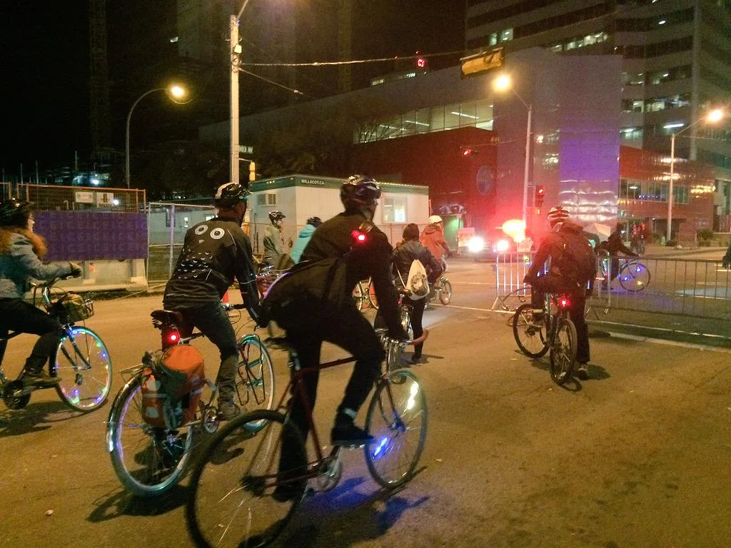
Chances are that when you cross the North Saskatchewan River by bike you take the High Level Bridge. It’s the easiest way of moving between north and south Edmonton, particularly for those that want to avoid sore legs and sweaty backs. As a result, over 2000 bikes and 1500 pedestrians used the bridge daily in the summer of 2013. While the journey across the bridge itself is a breeze (although too much of a breeze can make a ride on the east path a bit scary with its low guardrails), things get messy at intersections on its north and south ends, where pedestrians, cyclists, and drivers get pushed together.

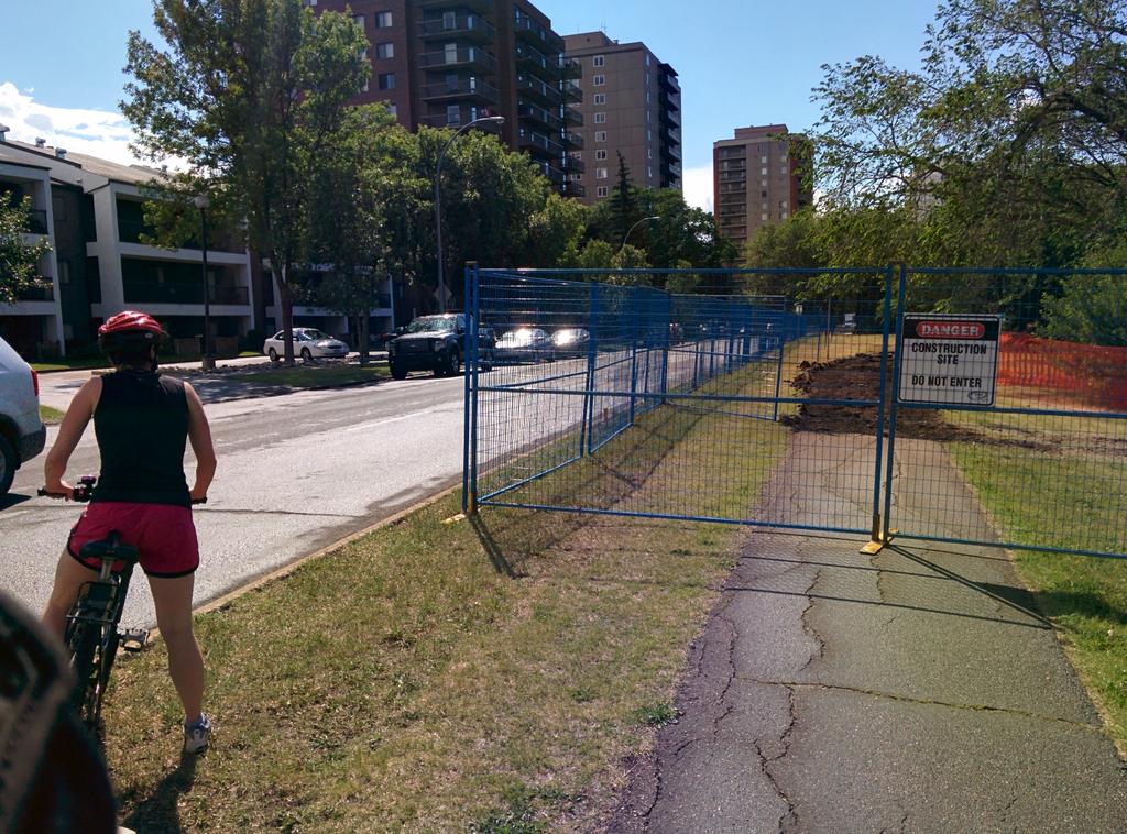
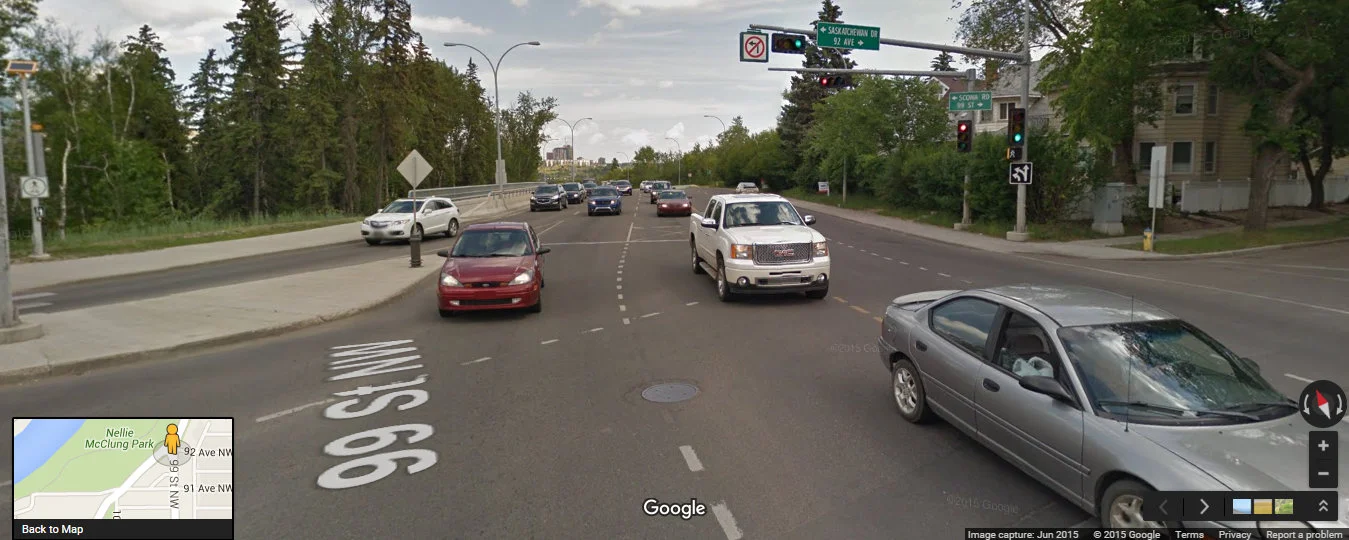
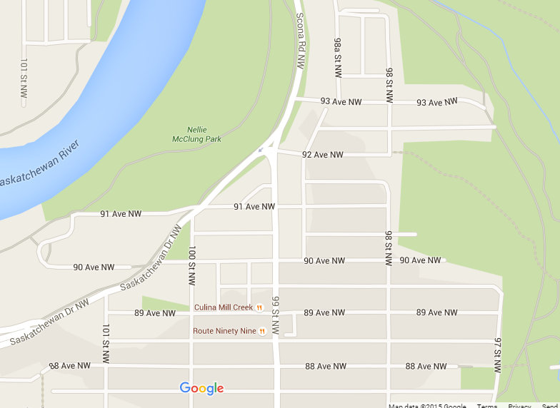
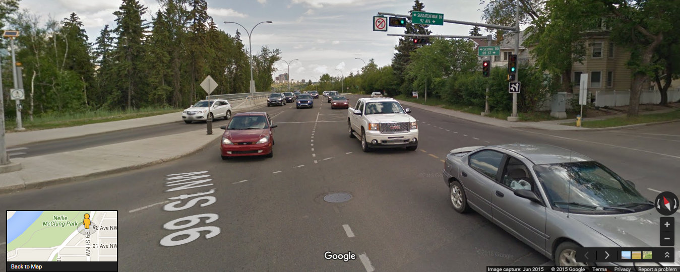
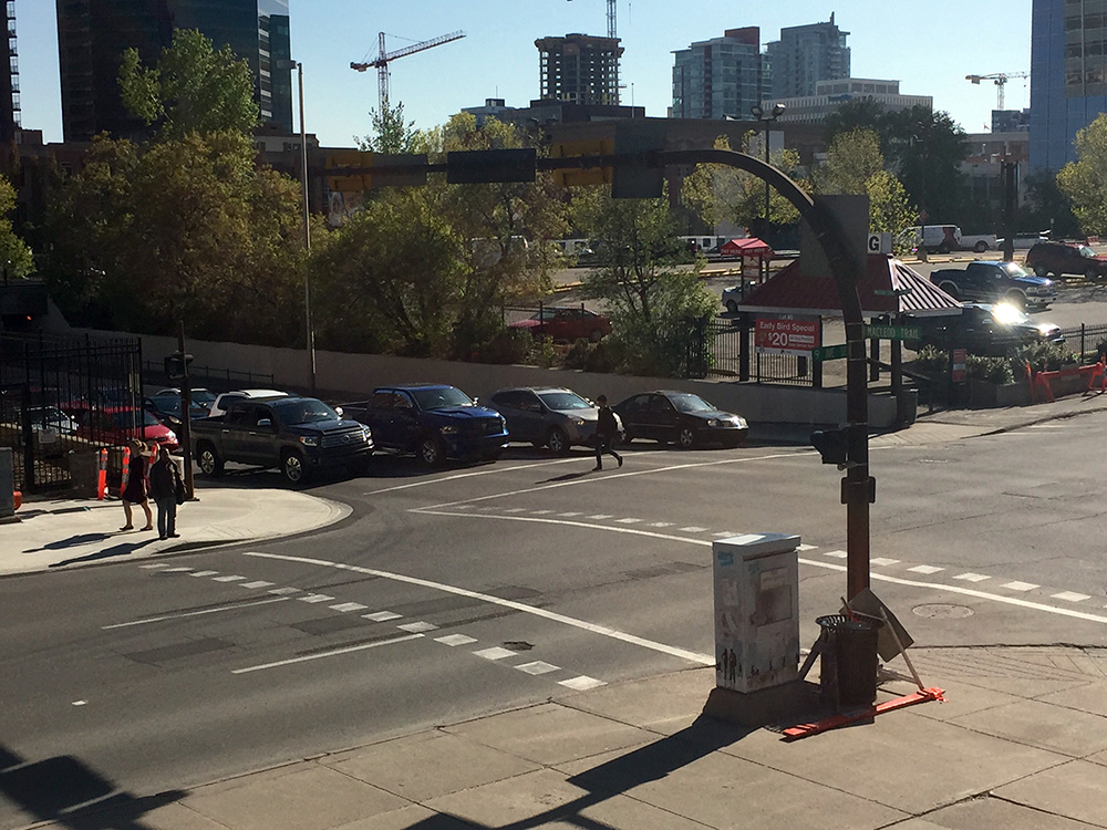
Let’s focus on the south intersection, where 88 Avenue, 109 Street, Saskatchewan Drive, and Walterdale Hill meet:
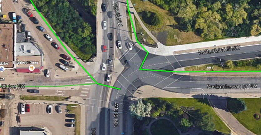
Aerial view of intersection with Google's bike route overlay (green): Google Maps

What's there


The intersection with current bike infrastructure shown

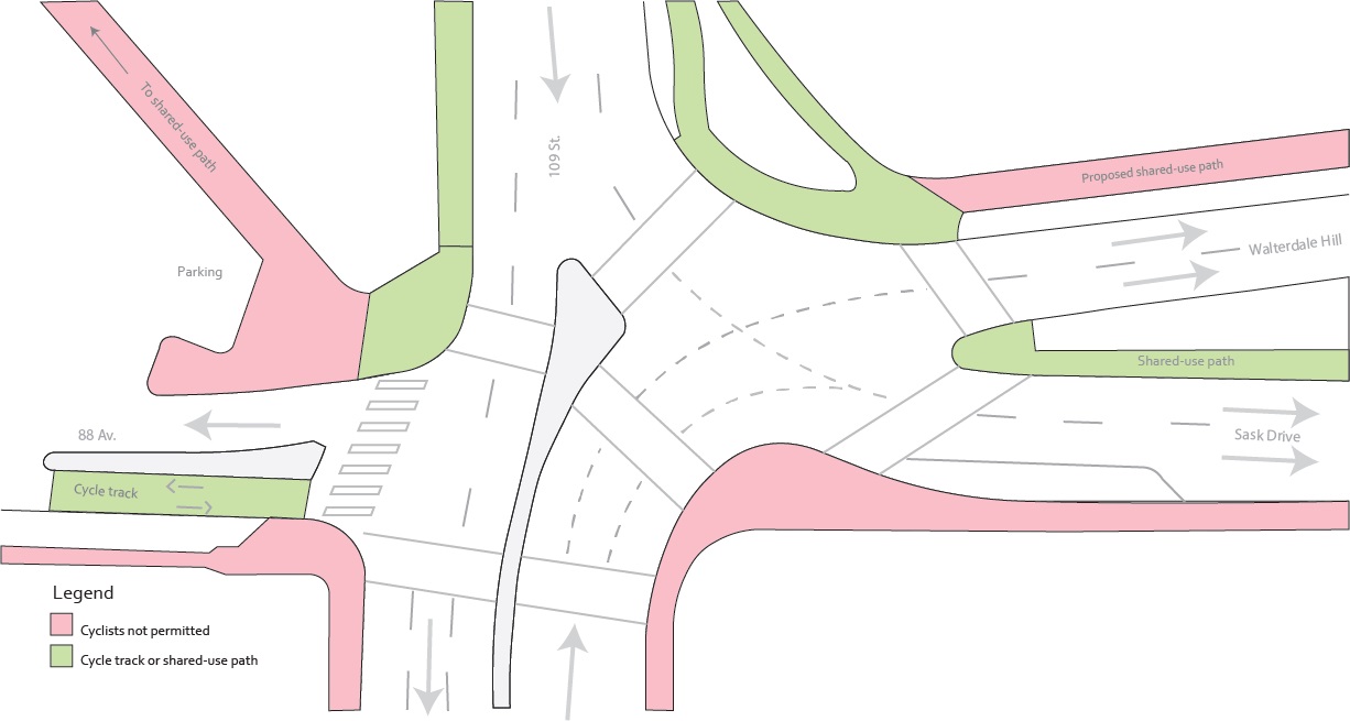
One of the most problematic features of this intersection is the design of the pedestrian and cyclist(?) crossings. I place a question mark after cyclist because there are no signs or design treatments designating the crossings for their use, although they are, in practice, heavily used by cyclists riding, not walking, their bikes alongside pedestrians. We only assume that cyclists are supposed to follow the pedestrian signals, which in some cities, like Montreal, could get you a ticket. Even Calgary has started marking locations where cyclists should follow the pedestrian signal. A constant refrain in the conversation around cyclists is that they are not pedestrians and should not be treated as such – however in this case (and most of Edmonton), there is no distinction made. (Note – Alberta law does allow people to ride through crosswalks without dismounting, though they are not afforded the right of way they would have while walking).

Pedestrian (and bike?) signals

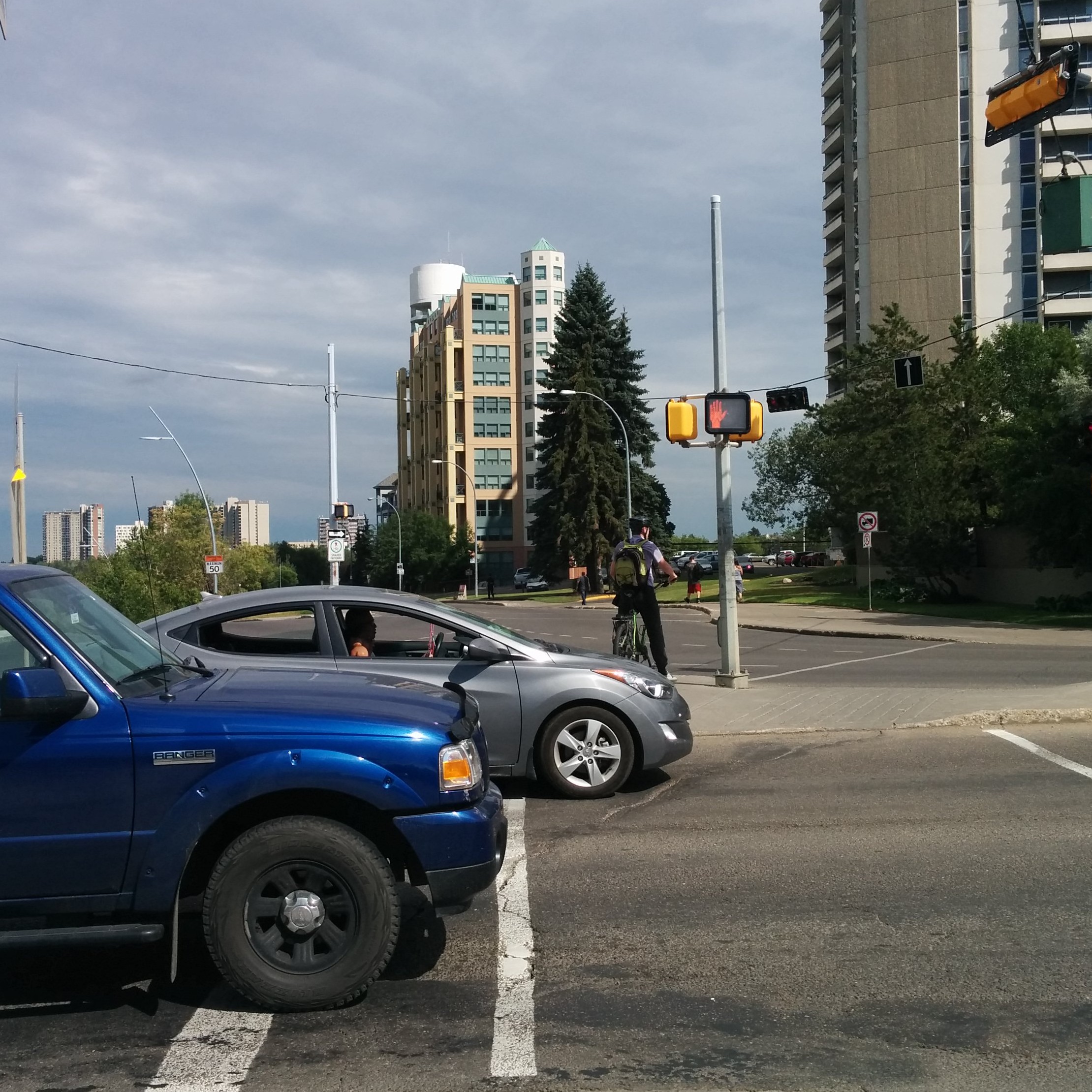
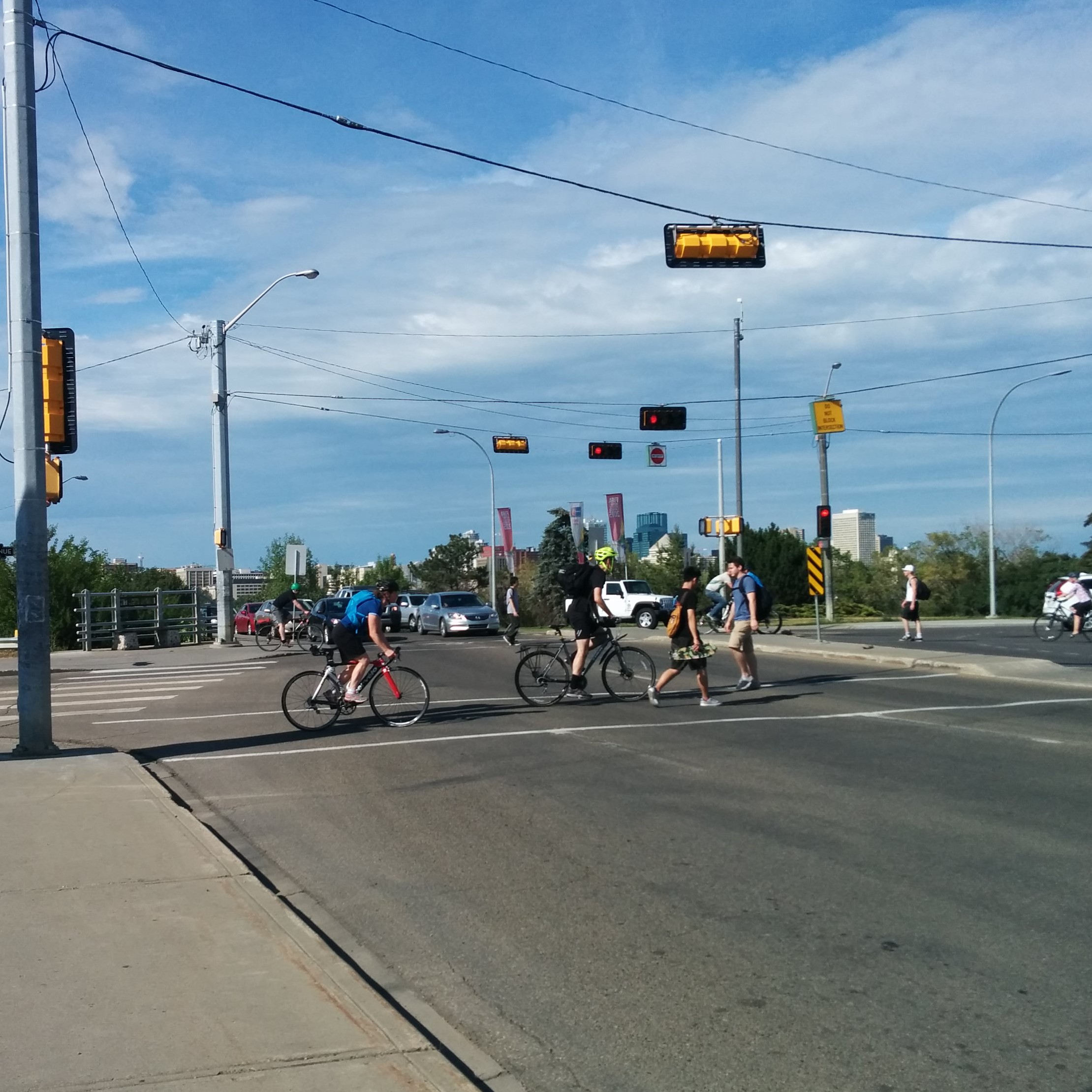
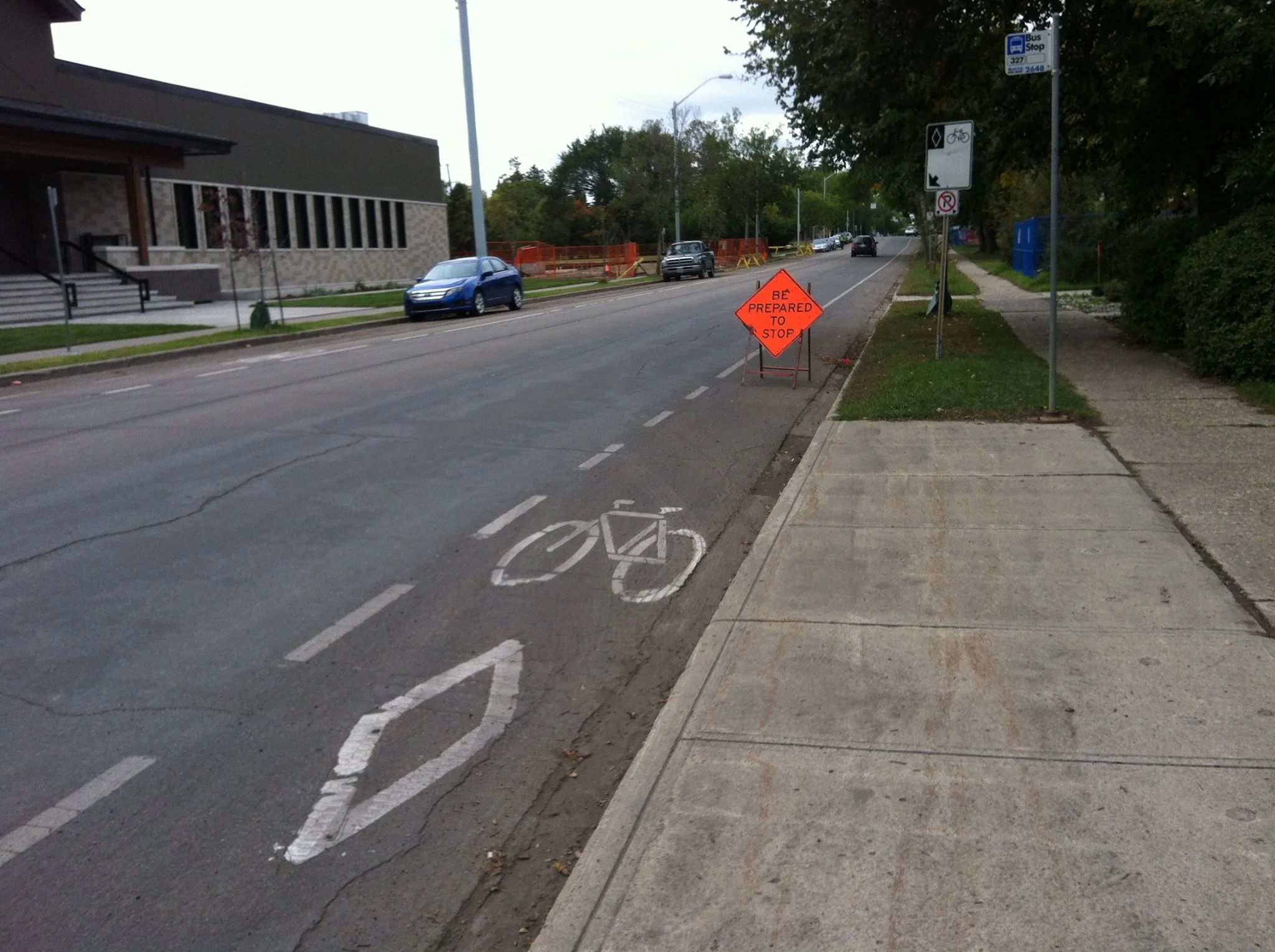
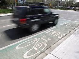
Important pieces of cycling infrastructure meet at this intersection, but it is hard to travel between them. To cross in most directions, cyclists are forced onto the sidewalk or a tiny island in the middle of the road. The existing (too narrow) shared-use path and short section of cycle track do not align and to travel straight between the two one must wait for at least one light cycle change (most likely lingering on the southeast corner with a crowd of pedestrians). Sometimes, the timing of the lights, which seem to be sequenced to maximise vehicular flow, can make your wait to cross painfully long. If you just miss the crossing signal when crossing from the cycle track to shared-use trail, you will spend 2 minutes and 15 seconds at this intersection alone! The actual crossings and curb cuts are so narrow that cyclists have barely enough room to squeeze past each other and pedestrians. In the below picture you can see another problem- there is no barrier preventing cars from using the cycle track to avoid the one-way westbound restriction on 88 Ave.

Looking east along the cycle track which ends abruptly at 109 Street.

Another problem is the abrupt end of the northbound bus-taxi-bike lane on 109 Street just before Saskatchewan Drive, which morphs into a right turn lane.

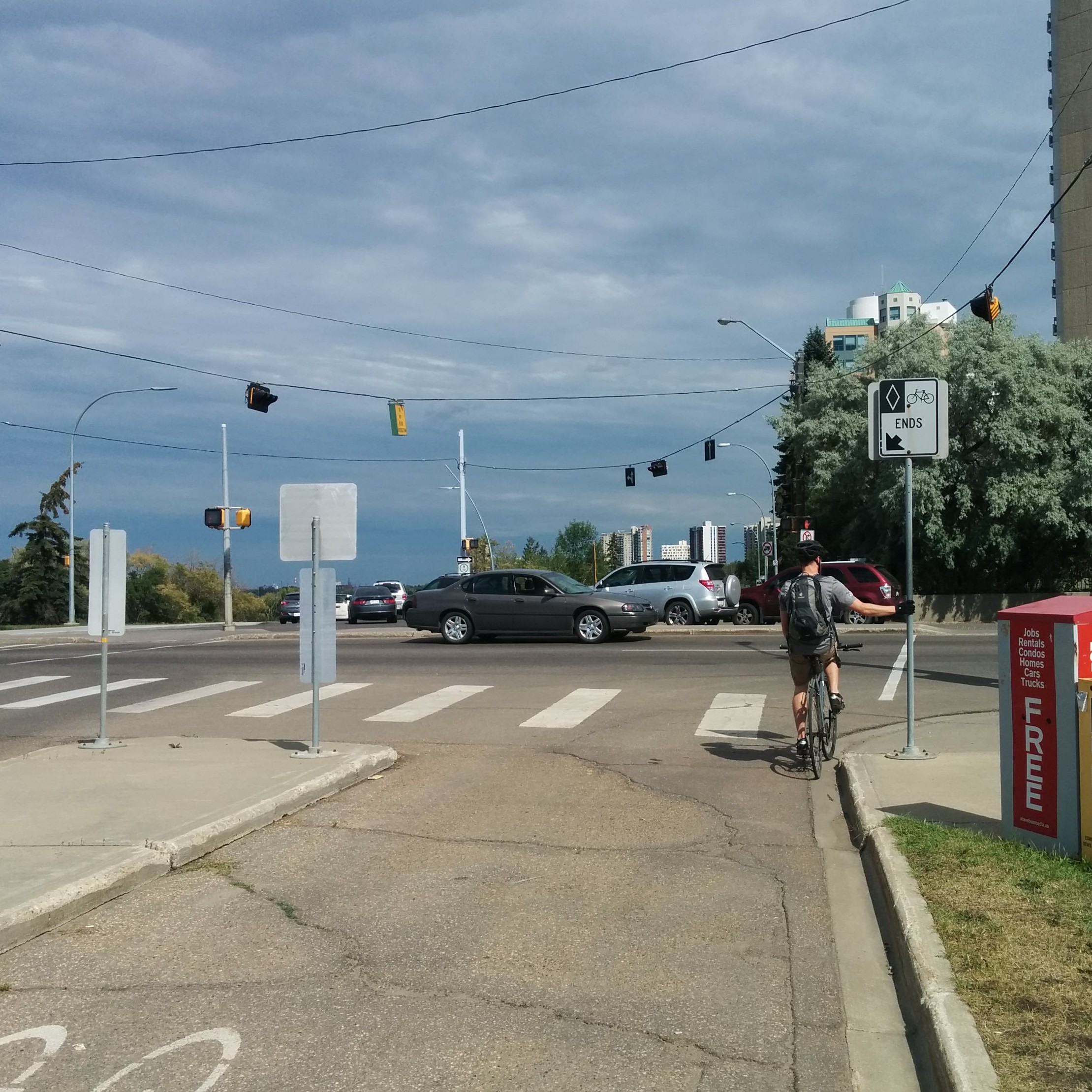
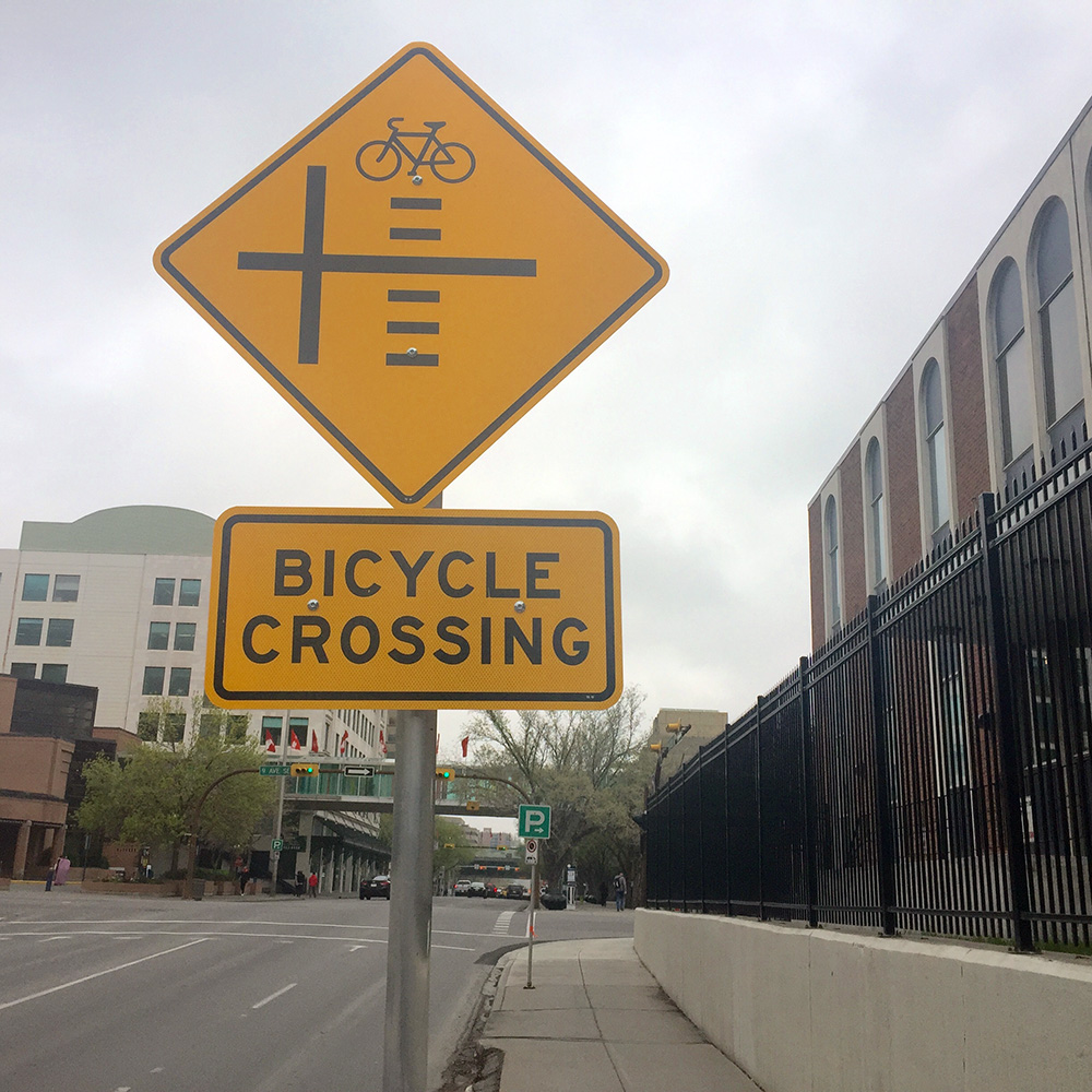
Making this situation worse is an almost complete lack of directional signage. Aside from signs marking the entrance and end to the cycle track and designating the path along Saskatchewan Drive as shared-use, there is nary a visual clue as to what people on bikes should do at this intersection. There was a sign on the north-west corner (now flipped around to make it unreadable) which pointed cyclists down the narrow sidewalk towards the bridge (rather than the shared-use path) – in this case the absence of signage is better than what was there before. Confusingly, however, this narrow sidewalk, from Walterdale Hill to the High Level Bridge is designated in the traffic bylaw as shared-use despite any corresponding signage (and its obvious unsuitability for that purpose).

Narrow crosswalks causing conflict

The lack of signage leads to a number of problems. Since no signs have been posted to designate the sections of sidewalk frequently used by cyclists to cross this intersection as shared-use paths, nearly every time a cyclist rides their bike through this intersection they are violating the traffic bylaw and could be subject to a $100 fine!  As will be seen below, the lack of directional signage also leads to cyclists making risky decisions, annoying pedestrians, and taking convoluted routes to get across the intersection.

How people on bikes use the intersection

I was inspired by Copenhagenize's desire lines methodology and spent a couple hours at this intersection recording cyclists’ routes and behaviour on a sunny Tuesday, July 7. By recording cyclists’ routes through the intersection we can learn how the intersection is functioning. Because of the volume of traffic and limited resources (i.e. coloured pens instead of a camera), I couldn’t track cyclists coming in all directions at once, so I focused on certain approaches for 15 minute periods, which could be aggregated for a 15 minute snapshot. This is a “cleaned up” version of what I observed:

Cyclist movements through intersection

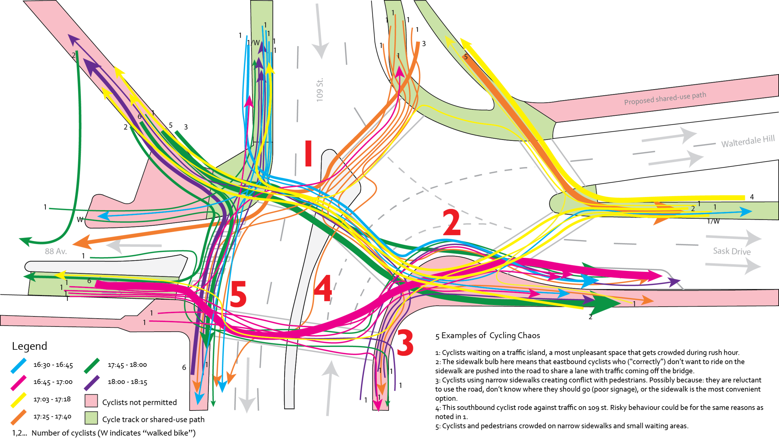
Perhaps an optimist would see the mess of different routes as an illustration of how free we are as cyclists to choose our way in a world that doesn’t remember us. However, from my experience riding through the intersection for several years, and observing it that afternoon, it is more a reaction to the absence of any safe and convenient paths, meaning that it is every cyclist for themselves. This becomes something of a problem when 80 cyclists use this intersection every 15 minutes during rush hour (according to these observations).

Unfortunately the design of this intersection encourages conflict (albeit mostly minor) within and between modes, risk-taking behaviour, and traffic bylaw violations. In addition to the conflicts noted in the above diagram, the vast majority of cyclists, 77 out of 80, did not dismount from their bicycles when crossing, which, while not required by law, is strongly encouraged by the City. Add in large volumes of traffic, a few unaware drivers who stop on the crossings when lights turn red, make unsafe right turns on red (prohibited here), or use the cycle track on 88 Ave as a way to avoid the one way, and you have a mess.

It was interesting to see how people navigated their way through the intersection. Most cyclists travelling east from 88 Ave would not use the shared-use path, but would instead ride across the crosswalk, cross the sidewalk bump-out, and merge onto Saskatchewan Drive (thick pink line). Similarly, most cyclists coming from the bridge and continuing east would not use the shared-use path, but instead would ride on Saskatchewan Drive or the sidewalk (blue and green lines). This is probably in part because the complicated crossing required to get onto the shared-use trail if you are coming from the west side of the bridge and because some of these cyclists will eventually head south. In the latter case, it is easier to turn right off of Saskatchewan Drive or its south sidewalk than trying to cross the road from the shared-use path on the north side. In contrast, cyclists coming south from the east side of the bridge WOULD use the shared-use path, as it was easily accessible with just one crossing (thick orange line). Most cyclists heading to or coming from the south used the sidewalks on 109th Street, which may point towards a need for better cycling infrastructure in that direction (clearly the disappearing bus-taxi-bike lane – which only is northbound – doesn’t cut it).

Wrap up

This post illustrates what is wrong with this intersection and how people on bikes currently cope with it. While it may not be the most dangerous or unpleasant intersection for cyclists in the city, its location at one end of the primary route for cyclists across the river and on a major east-west corridor is reason enough for improvement. Its current form is hazardous, confusing, and inconvenient for cyclists, as well as the hundreds of pedestrians who also share (or often compete for) the limited space not dedicated to motor vehicles. If the City is serious about implementing the principles contained within the Way We Move, the Complete Street Guidelines, and following through on its recent decision to improve cycling infrastructure in central areas, this intersection should be high on the list.

Of course, this is also an important and busy intersection for drivers, and is made more challenging by the number of one way streets which meet at it. Any design solutions must recognise that, but attempt to strike a better balance between all modes. Part 2 of this post will propose a few solutions – some simple, some drastic – that will make this a more pleasant intersection for cyclists and pedestrians, without unduly affecting motorised transportation.

This post is written by Michael O'Neill. Michael is a proud Edmontonian currently based in Montreal while he completes his Master of Urban Planning at McGill University. He rides bikes for fun and as his main way of getting around, but also walks, takes transit, and drives. He's thrilled to have the opportunity to write about cycling issues in Edmonton, and hopes that even if you disagree with his ideas, it will get you thinking about how improvements can be made. You can leave a comment on this post with any questions, or you can contact him directly via email at [email protected]

[show-panel id="8968" left=1 ispagenotpost=0]