


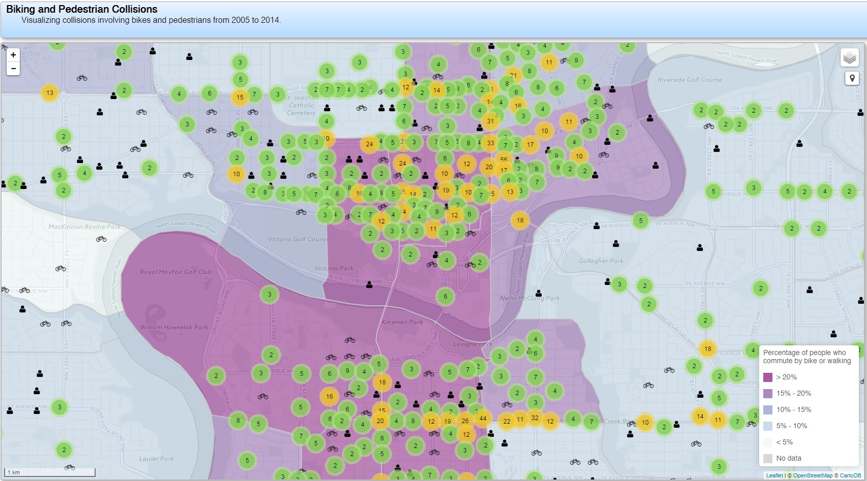
Paths for People (formerly the Edmonton Bike Coalition) today released an interactive online map showing 10 years of collisions in Edmonton between cars and people walking or riding their bikes. The Edmonton Journal has covered the story.
“We got the data from the City of Edmonton through a FOIP request and we are making it accessible to residents who are concerned about getting around their neighbourhoods safely” said Paths for People member Conrad Nobert. “Over the past 10 years, more than 5,400 people biking or walking have been hit while trying to get around. That’s three Edmontonians every two days being hit and either injured or killed.”
The group is calling on the City of Edmonton to begin prioritizing safety for people outside of automobiles. “The City should begin looking at our roads as part of a system that is currently failing us. That system is dangerous to human health because of its design”, said Dr. Darren Markland, member of the group and Critical Care Physician and Nephrologist at the Royal Alexandra Hospital in Edmonton. “If a company ran factories that caused 1.5 injuries and/or deaths every day, it would implement measures to drastically reduce that number. We’re asking City Council and Administration to step in and make our roads safer”.
Specifically, Paths for People is asking the City to change the default speed on residential roads (not the busier collector and arterial roads) to 30 km/h. “Residential speeds of 50 km/h are very dangerous, and they are inappropriate for streets on which our kids play and our seniors walk”, said Nobert. “30 km/h is becoming the international standard for safe residential streets because death and serious injuries plummet at that speed.”
Furthermore, Paths for People is calling on the City to redesign the more dangerous stretches of road, such as 109 Street, 99 Street, 118 Avenue, Whyte Avenue, and many others, using its Complete Streets Design Guidelines (Complete Streets "enable safe, convenient and comfortable travel and access for users of all ages and abilities regardless of their mode of transportation" ). “It’s obvious that these stretches of road are highly dangerous to people outside of cars. The City can and should do the right thing and make these hot spots safe for all road users,” added Markland.
Finally, the group is calling for future neighbourhood and arterial renewal programs to automatically redesign streets to be safer and more comfortable for people on bikes and on foot. “When we are investing millions to renew a neighbourhood or a road, it makes perfect sense to redesign with an emphasis on the safety and comfort of people outside of automobiles”, said Nobert.
“We hope that community residents will use our map to answer for themselves whether the City is keeping their neighbourhood streets safe. Everyone should be able to make healthy choices such as biking or walking without fear of being hit. We encourage people to look at the map and ask their City Councillors how they plan to make a safe, walkable, bikeable Edmonton”, Nobert said. The map can be found at Paths for People’s website here. More information about our ask is here.
The map can be found at Paths for People’s website, as well as more information about their ask.
Paths for People invites you to help create and envision an active, healthy and engaged Edmonton. In partnership with the City of Edmonton, Paths for People are pleased to welcome Gil Penalosa, founder of 8-80 Cities to talk with Edmontonians on April 15, 2016 about his vision of a City that is liveable for all. An informal reception will follow, where a map of potential bike/walk corridors for Edmonton will be displayed, and poster presentations on sustainable transportation will be presented by local Engineering firms.
More information can be found on the event website.