
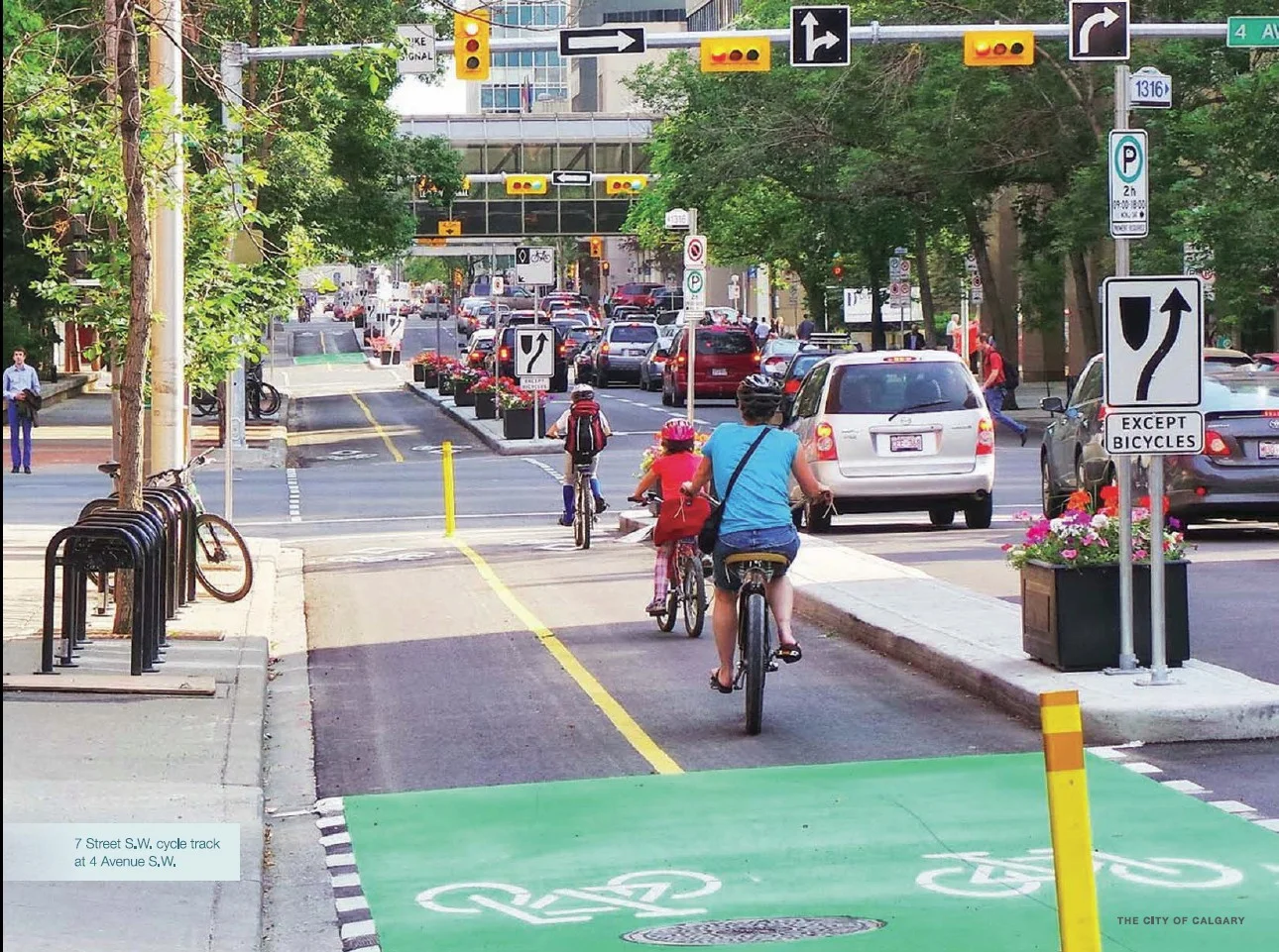

Just days after the unveiling of designs for the 83 Avenue and 102 Avenue protected bike lanes, and sandwiched in-between the 102 Avenue and 83 Avenue bike route public workshops on April 21 and April 23, the agenda for next week's Transportation Committee Meeting is packed with bicycle-related items. The agenda includes:
Reports
Responses to Councillor Inquiries
Reports
6.3. Performance Standards and Clear Measures - Bike Lanes
At the October 15, 2014, Transportation Committee meeting, the following motion was passed:
That Administration provide a report on the development of performance standards including clear measures and targets for existing and future bike lane ridership.
Report Summary
This report summarizes the proposed approaches to performance monitoring of the Bicycle Program through a Bicycle Program Annual Report and reviewing the performance of individual bicycle routes through an Annual Bicycle Route Review Program.
Performance measures and targets currently exist for city-wide performance of the Bicycle Program (i.e. The Way Ahead: Commute to work non-auto driver mode share, Target of 25.9% by 2018) and a number of additional measures are proposed. Results of the City-wide Bicycle Program performance monitoring and evaluation would be included in an Annual Report. […]
One interesting finding of the report, which included a review of industry best practices across North America, was that no cases were found of any city setting performance targets for individual bike routes.
Through the review, no examples could be found where cities had specific targets for the ridership or safety performance that individual bicycle routes had to achieve, but there was a common objective to increase ridership and safety and support objectives of accessibility, affordability, and livability. The only time when a target was found was when an entire connected network was being piloted and evaluated. Cities consistently measure and have targets for cycling mode share and collision statistics because bicycle networks in North American cities are in their infancy and not yet complete. North American cities are focusing on the creation of completed bicycle networks in order to provide safe bicycle access from people's homes to the places they need or want to travel to. […]
The full report can be reviewed online.
Details of measures to be collected and reported on annually are included in a separate attachment.
6.4. Alternative Bike Lane for 95 Avenue
At the October 15, 2014, Transportation Committee meeting, the following motion was passed:
That Administration provide a report outlining the cost and feasibility of relocating the bike lane on 95 Avenue to the service road.
Report Summary
This report responds to questions regarding the on-street bike route on 95 Avenue in west Edmonton. A Safety and Operational Review was completed on the 95 Avenue corridor, and the results indicated that the corridor was operating safely with some improvements identified. Alternative bike route designs were explored between 163 and 156 Streets, and the cost to implement these alternatives is in the order of $1.1 million, although the benefits to both vehicle and cyclist traffic were found to be marginal. In 2015, Administration will be making some localized improvements to the 95 Avenue corridor for improved performance.
The impetus for the motion that prompted this report is the feeling from drivers using 95 Ave that the change from a 4-lane roadway to a 3-lane with centre turning lane had a large, negative impact on vehicle travel times, and that people riding bikes would feel safer using the service road rather than the on-street bike lane.
On the first point, the City's analysis indicates that the potential change with the biggest benefit to travel time would be to increase the east-west traffic signal timing at 163 St, which can be done whether or not the bike route itself is changed. Currently, 95 Ave in the stretch between 156 St to 163 St is a 3-lane road, where the middle lane is a left-turn lane. Increasing this to a 4-lane roadway, where 2 of the lanes are shared left-turning lanes, would only have a marginal impact, as they would operate similarly to the current road whenever two cars wish to make left turns at an intersection.
The second point, that people riding bikes would feel or be safer on the service road, is a less easily-quantifiable argument. Most car-bike collisions happen at intersections, and increasing the number of conflict points by moving the route to the service road, as well as on and off short sections of sub-standard shared-use sidewalks, is unlikely to have a positive impact on actual safety. Perceived safety is another question: if cyclists feel better about the service road option, but are actually no more safe (or perhaps even less safe), is it still worth spending $1.1 million to relocate the bike route?
The report notes that improvements to signal timing and intersection design, as well as pavement markings and signage, will be occurring and will be funded through the Active Transportation budget. These changes will hopefully mitigate some of the traffic and safety issues that the original motion hoped to address.
Our position is that, once those changes are made, there are more important spending priorities for the City than pursuing this bike route relocation.
You can read the full report on the City's website.
Perhaps the most interesting part of the report is the analysis:
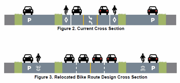
Analysis of the Potential Relocated Bike Route Design
The benefits of relocating the bike route from 95 Avenue to the adjacent service roads are limited. The major benefit that is achieved is the suggested redesign of the 163 Street intersections which may improve the safety and operation of the intersection for people driving, walking, and biking by improving sightlines and reducing right turning vehicle speeds. This improvement could be done with or without relocating the route. While relocating the on-street bike route from 95 Avenue to the adjacent service roads between 156 Street and 163 Street adds one vehicle traffic lane, this added lane serves as a shared left turn and through lane at the intersections. Due to this operation, analysis of traffic operations indicates that adding a single lane would only marginally improve vehicle level of service and delay. For bicycle operations, shifting the route to the service roads would add delay for those travelling by bike due to the stop signs located at intersecting streets. Locating the bike route onto the service roads adds some complexity to the route. The relocation of the route to the service roads would require cyclists to transition into and out of the service roads at a number of locations, cyclists would be using pedestrian crossings at 156 Street and 163 Street, and the number of conflicts at intersecting streets is higher than with the route along 95 Avenue. The design would also require the construction of shared-use paths which, due to right-of-way constraints, would be narrower than City standards and would provide limited clearances from the adjacent roadway or utility poles.
Conclusions
Based on the analysis completed, relocating the 95 Avenue bicycle route to the service roads between 156 Street and 163 Street is feasible but is not recommended based on the cost of the upgrade, that the upgrade would only pertain to a portion of the corridor, and limited benefits can be achieved related to operations or safety for either motorists or cyclists. To achieve significant benefits, a redesign of the entire 95 Avenue bicycle route would be required from 142 Street through to 189 Street. This would allow for a consistent design of the 95 Avenue corridor.
Responses to Councillor Inquiries
7.1. Bike Lane Removal (M. Nickel)
Report Summary
This report responds to questions regarding the 97 Street on-street bike route between 34 Avenue and 63 Avenue.
At the October 22, 2014, City Council meeting, Councillor M. Nickel made the following inquiry:
Maintaining balance between travel modes as well as achieving the support of communities and stakeholders are important parts of creating a healthy, multi-modal city. In some cases when changes to travel modes are made, the unintended consequences for commuters and communities are felt more by some stakeholders than others. Can Administration provide information on the current status of 97th Street Bike Lanes south of 63rd Avenue (to 34th Avenue), specifically including information on: 1. The impact of the bike lane installations on the neighbouring industrial/commercial communities as determined through community consultation. 2. The value of the 97th Street north south route to the bicycle community as a connector between destinations as determined by community and stakeholder consultation. 3. Alternate routes that could be considered that would provide similar bicycle network connectivity. 4. The cost of relocating 97th street Bike Lane to a location with similar connectivity.
Because of the nature of councillor inquiries, there were no resources allocated for City administration to answer this inquiry; they must answer using information they have readily available. This leads to an interesting report where the post-installation community & stakeholder consultation aspect consists of feedback which was provided to the City.
The impact of the bike lane installations on the neighbouring industrial/commercial communities as determined through community consultation. To respond to this part of the inquiry, consultation related to the impacts the bike lanes have had on the community was limited to reviewing the input from an informal petition received by Councillor M. Nickel’s office from businesses along 97 Street. The informal petition was received from Councillor M. Nickel’s office in November, 2014. The petition asked, “Do you support the removal of Bike Lanes in your neighbourhood.” It is unknown how the signatures were collected or when they were collected. The informal petition gathered 193 distinct signatures of which 187 supported removing bike lanes. Of those in support for removing bike lanes, 93 individuals specifically referenced a reason for their concern: 32% mentioned low ridership, 15% traffic safety, 9% traffic congestion, and 8% removal of parking.
Alternate routes suggested included 91 St and 99 St. Travelling to 91 St represents a round-trip detour of at least 1600m. However, there are very few east-west connections from the neighbourhood out to 91 St. Those connections consist of the arterial roadways 34 Ave, 51 Ave, and 63 Ave, and the industrial collectors 39 Ave and 58 Ave: only five crossings in the entire stretch from 34 Ave to 63 Ave, with a 1.6km gap in the middle across Whitemud Dr. This means the average detour is likely closer to 2 to 2.5km, and requires two crossings of 91 St at major intersections. Even with the extra detour, cycling along 97 St is still required to reach a final destination within the neighbourhood. All of these reasons make 91 St an unacceptable alternative to providing safe cycling access to the areas currently served by 97 St.
99 St would be an acceptable alternative if a physically separated, protected bike lane were constructed. This would require much greater expense as well as the removal of existing travel lanes on 99 St. Clearly there is little appetite for such an option.
The only option that we would endorse, if the cost were supported by the findings of a safety and operational review, is upgrading 97 St to improve safety and traffic flow.

Another alternative to the existing 97 Street bike route is to upgrade the route to improve operations and enhance safety. 97 Street has sufficient width to allow for the addition of left turn bays at collector and local road intersections. This upgrade would require narrowing the existing bike lanes at each intersection to accommodate the turn bays, but would result in reduced delay for vehicles and may improve safety.
In addition, the upgraded 97 Street alternative could include the restriping of pavement markings leading up to the intersections at 34 Avenue, 51 Avenue, and 63 Avenue to install on-street bike lanes rather than the existing single file shared-use lanes. This would be achieved by slightly narrowing the existing travel lanes. This enhancement would increase the comfort level of the on-street bike route for people riding bikes and would reduce delay for those driving by providing a separate space for the slower moving bicycles to operate at these arterial intersections.
The full report is available here.
7.2. Bike Lanes on Utility Corridors (E. Gibbons)
Report Summary
This report outlines the strategic documents and planning context for potential bike routes along Utility Corridors.
At the August 21, 2013, Transportation Committee meeting, Councillor E. Gibbons made the following inquiry:
Considering the amount of public objection to bike lanes, especially those on busy roads and intersections, I would like Administration to provide a report describing what kind of alternatives exist for bicycle traffic on Utility Corridors, that includes answers to the following:
Has the City looked into bike lanes and/or trails along Utility Corridors (both Pipeline and Powerline)? Considering the impending completion of the Anthony Henday, what potential exists for incorporating bike lanes and/or trails along the Utility Corridors of the ring road while construction continues? Is it possible to locate recreational bike trails along Utility Corridors? Would Utility Corridors be feasible locations for commuter bike lanes?
The summary of this report is that there are plans, policies, and partnerships that build shared-use paths along parkland, rail, and utility corridors whenever possible, and there are many existing pathways that have already been constructed along these corridors. You can read the full report for the details. Perhaps the most interesting part of this report is this last sentence:
Finally, Administration is completing a major GIS mapping exercise that will allow for continued strategic identification of gaps in the shared-use path network and improved network connectivity. This map will be available later this year.
Better tools and better maps can only help in developing a better transportation network.
EBC will be present at the April 22 Transportation Committee meeting to provide our input on these reports. You too can register to speak on these or any of the other agenda items by completing the City of Edmonton's Request to Speak form.