
Bicycle Bottleneck - Part 1

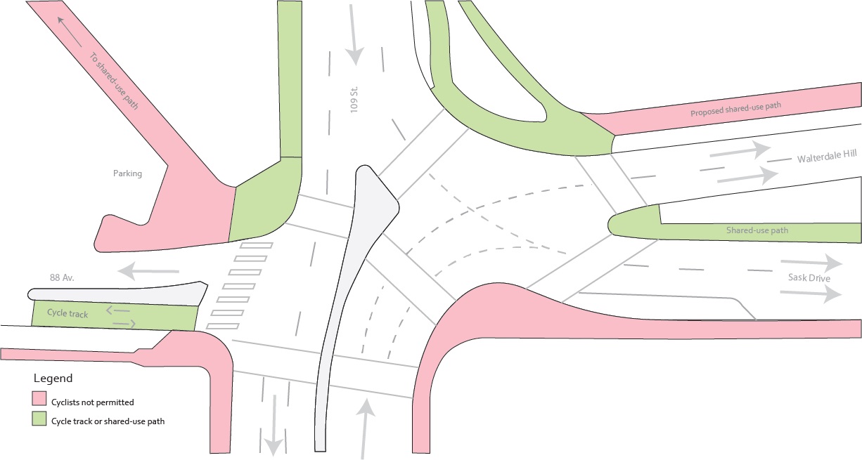
109-and-Sask-Drive-Paths.png

Chances are that when you cross the North Saskatchewan River by bike you take the High Level Bridge. It’s the easiest way of moving between north and south Edmonton, particularly for those that want to avoid sore legs and sweaty backs. As a result, over 2000 bikes and 1500 pedestrians used the bridge daily in the summer of 2013. While the journey across the bridge itself is a breeze (although too much of a breeze can make a ride on the east path a bit scary with its low guardrails), things get messy at intersections on its north and south ends, where pedestrians, cyclists, and drivers get pushed together.

Let’s focus on the south intersection, where 88 Avenue, 109 Street, Saskatchewan Drive, and Walterdale Hill meet:
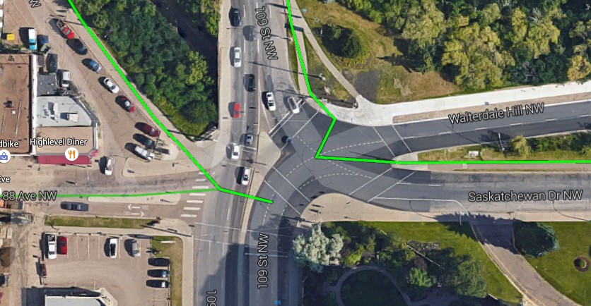
Aerial view of intersection with Google's bike route overlay (green): Google Maps

What's there


The intersection with current bike infrastructure shown

One of the most problematic features of this intersection is the design of the pedestrian and cyclist(?) crossings. I place a question mark after cyclist because there are no signs or design treatments designating the crossings for their use, although they are, in practice, heavily used by cyclists riding, not walking, their bikes alongside pedestrians. We only assume that cyclists are supposed to follow the pedestrian signals, which in some cities, like Montreal, could get you a ticket. Even Calgary has started marking locations where cyclists should follow the pedestrian signal. A constant refrain in the conversation around cyclists is that they are not pedestrians and should not be treated as such – however in this case (and most of Edmonton), there is no distinction made. (Note – Alberta law does allow people to ride through crosswalks without dismounting, though they are not afforded the right of way they would have while walking).
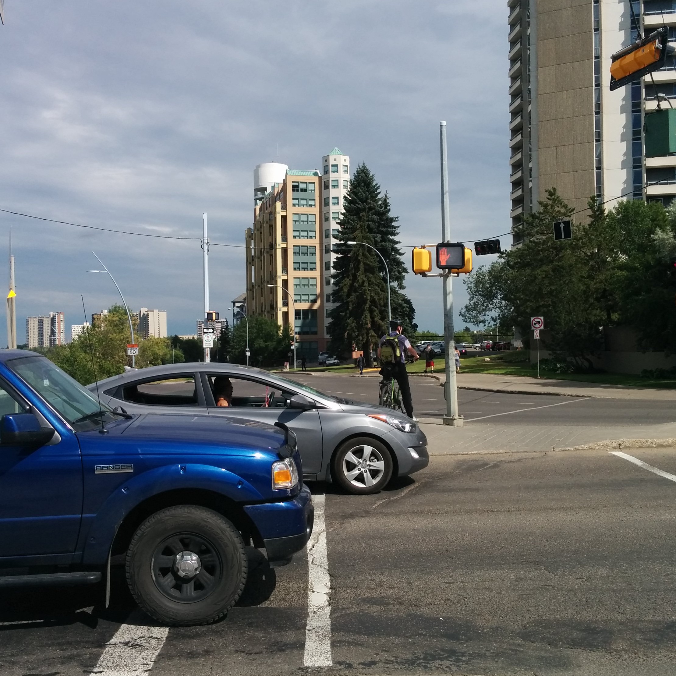
Pedestrian (and bike?) signals

Important pieces of cycling infrastructure meet at this intersection, but it is hard to travel between them. To cross in most directions, cyclists are forced onto the sidewalk or a tiny island in the middle of the road. The existing (too narrow) shared-use path and short section of cycle track do not align and to travel straight between the two one must wait for at least one light cycle change (most likely lingering on the southeast corner with a crowd of pedestrians). Sometimes, the timing of the lights, which seem to be sequenced to maximise vehicular flow, can make your wait to cross painfully long. If you just miss the crossing signal when crossing from the cycle track to shared-use trail, you will spend 2 minutes and 15 seconds at this intersection alone! The actual crossings and curb cuts are so narrow that cyclists have barely enough room to squeeze past each other and pedestrians. In the below picture you can see another problem- there is no barrier preventing cars from using the cycle track to avoid the one-way westbound restriction on 88 Ave.
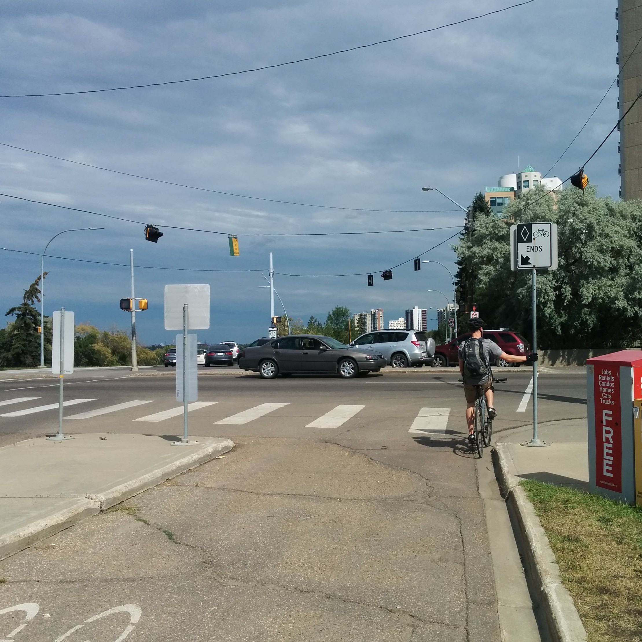
Looking east along the cycle track which ends abruptly at 109 Street.

Another problem is the abrupt end of the northbound bus-taxi-bike lane on 109 Street just before Saskatchewan Drive, which morphs into a right turn lane.

Making this situation worse is an almost complete lack of directional signage. Aside from signs marking the entrance and end to the cycle track and designating the path along Saskatchewan Drive as shared-use, there is nary a visual clue as to what people on bikes should do at this intersection. There was a sign on the north-west corner (now flipped around to make it unreadable) which pointed cyclists down the narrow sidewalk towards the bridge (rather than the shared-use path) – in this case the absence of signage is better than what was there before. Confusingly, however, this narrow sidewalk, from Walterdale Hill to the High Level Bridge is designated in the traffic bylaw as shared-use despite any corresponding signage (and its obvious unsuitability for that purpose).
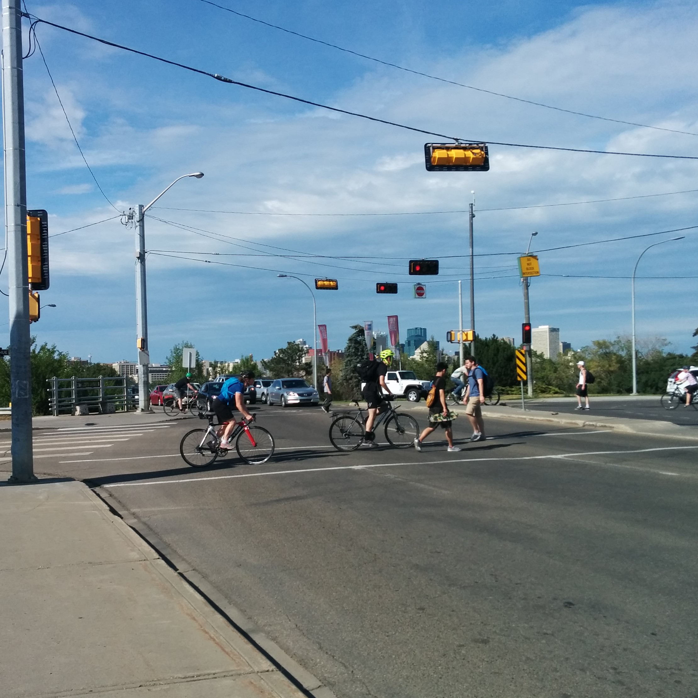
Narrow crosswalks causing conflict

The lack of signage leads to a number of problems. Since no signs have been posted to designate the sections of sidewalk frequently used by cyclists to cross this intersection as shared-use paths, nearly every time a cyclist rides their bike through this intersection they are violating the traffic bylaw and could be subject to a $100 fine!  As will be seen below, the lack of directional signage also leads to cyclists making risky decisions, annoying pedestrians, and taking convoluted routes to get across the intersection.

How people on bikes use the intersection

I was inspired by Copenhagenize's desire lines methodology and spent a couple hours at this intersection recording cyclists’ routes and behaviour on a sunny Tuesday, July 7. By recording cyclists’ routes through the intersection we can learn how the intersection is functioning. Because of the volume of traffic and limited resources (i.e. coloured pens instead of a camera), I couldn’t track cyclists coming in all directions at once, so I focused on certain approaches for 15 minute periods, which could be aggregated for a 15 minute snapshot. This is a “cleaned up” version of what I observed:
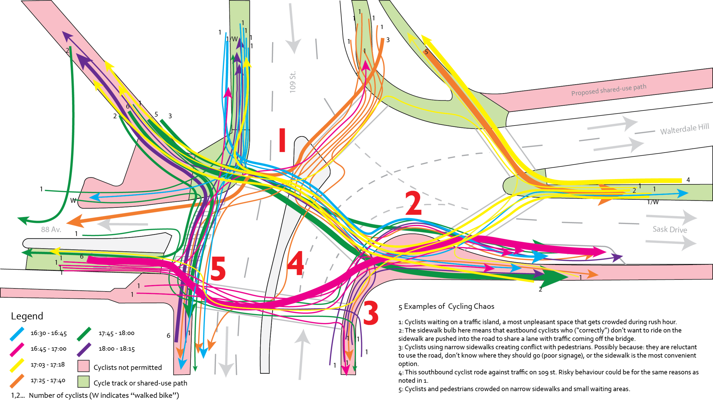
Cyclist movements through intersection

Perhaps an optimist would see the mess of different routes as an illustration of how free we are as cyclists to choose our way in a world that doesn’t remember us. However, from my experience riding through the intersection for several years, and observing it that afternoon, it is more a reaction to the absence of any safe and convenient paths, meaning that it is every cyclist for themselves. This becomes something of a problem when 80 cyclists use this intersection every 15 minutes during rush hour (according to these observations).

Unfortunately the design of this intersection encourages conflict (albeit mostly minor) within and between modes, risk-taking behaviour, and traffic bylaw violations. In addition to the conflicts noted in the above diagram, the vast majority of cyclists, 77 out of 80, did not dismount from their bicycles when crossing, which, while not required by law, is strongly encouraged by the City. Add in large volumes of traffic, a few unaware drivers who stop on the crossings when lights turn red, make unsafe right turns on red (prohibited here), or use the cycle track on 88 Ave as a way to avoid the one way, and you have a mess.

It was interesting to see how people navigated their way through the intersection. Most cyclists travelling east from 88 Ave would not use the shared-use path, but would instead ride across the crosswalk, cross the sidewalk bump-out, and merge onto Saskatchewan Drive (thick pink line). Similarly, most cyclists coming from the bridge and continuing east would not use the shared-use path, but instead would ride on Saskatchewan Drive or the sidewalk (blue and green lines). This is probably in part because the complicated crossing required to get onto the shared-use trail if you are coming from the west side of the bridge and because some of these cyclists will eventually head south. In the latter case, it is easier to turn right off of Saskatchewan Drive or its south sidewalk than trying to cross the road from the shared-use path on the north side. In contrast, cyclists coming south from the east side of the bridge WOULD use the shared-use path, as it was easily accessible with just one crossing (thick orange line). Most cyclists heading to or coming from the south used the sidewalks on 109th Street, which may point towards a need for better cycling infrastructure in that direction (clearly the disappearing bus-taxi-bike lane – which only is northbound – doesn’t cut it).

Wrap up

This post illustrates what is wrong with this intersection and how people on bikes currently cope with it. While it may not be the most dangerous or unpleasant intersection for cyclists in the city, its location at one end of the primary route for cyclists across the river and on a major east-west corridor is reason enough for improvement. Its current form is hazardous, confusing, and inconvenient for cyclists, as well as the hundreds of pedestrians who also share (or often compete for) the limited space not dedicated to motor vehicles. If the City is serious about implementing the principles contained within the Way We Move, the Complete Street Guidelines, and following through on its recent decision to improve cycling infrastructure in central areas, this intersection should be high on the list.

Of course, this is also an important and busy intersection for drivers, and is made more challenging by the number of one way streets which meet at it. Any design solutions must recognise that, but attempt to strike a better balance between all modes. Part 2 of this post will propose a few solutions – some simple, some drastic – that will make this a more pleasant intersection for cyclists and pedestrians, without unduly affecting motorised transportation.

This post is written by Michael O'Neill. Michael is a proud Edmontonian currently based in Montreal while he completes his Master of Urban Planning at McGill University. He rides bikes for fun and as his main way of getting around, but also walks, takes transit, and drives. He's thrilled to have the opportunity to write about cycling issues in Edmonton, and hopes that even if you disagree with his ideas, it will get you thinking about how improvements can be made. You can leave a comment on this post with any questions, or you can contact him directly via email at [email protected]

[show-panel id="8968" left=1 ispagenotpost=0]

Jean François Pronovost keynotes Alberta Bicycle Commuters Conference

RV_accueil_1g.jpg

How do you build the longest bicycle greenway in the world? You can ask Jean François Pronovost, one of the architects (figuratively speaking--he was originally trained as a biologist) of Quebec's 5000km La Route Verte at next month's Alberta Bicycle Commuters Conference.

The conference takes place September 26-27, 2015 at the Coast Canmore Hotel and Conference Centre. More information, including registration and accommodations, can be found on the conference website.

Get On Board!

11130436_10153200783594501_5409974081746779488_o.jpg

Our Annual General Meeting (AGM) is coming up on October 4, 2015 and to prepare we're recruiting for some positions on our board of directors. If you or someone you know have experience in not-for-profit governance, or you would love to work behind-the-scenes to grease EBC's organizational gears, please apply to be on our board!

Applicants will be considered by our membership at the AGM and voted in.

Applications can be completed online at: http://edmontonbikes.ca/nominations

The Yards: Who's Afraid of the Big Bad Bike Lane?

Yards-bannerlogo-01.png

From The Yards, Edmonton's quarterly magazine about downtown Edmonton’s transformation and growth, comes an in-depth conversation on Edmonton's bike lanes and road culture:

Recorded just weeks before City Council voted to scrape off the largest on-road bike route in Edmonton, a writer and former bike courier discusses the progress and set backs of building decent bike infrastructure in Edmonton. Is there enough political will to deliver on this key element of the city's active transportation strategy?

Job posting: Program Coordinator for The Spoke & You Can Ride 2

EBClogo-300ppi-623x3802.png

Here is your chance to join the team at EBC and get paid to help make Edmonton a better city while working with volunteers and with youth.

Program Coordinator: The Spoke & You Can Ride 2

The Program Coordinator is a new position within EBC and will be the touch point in the organization for The Spoke and You Can Ride 2. The primary duty of the Program Coordinator is to manage the ongoing operations of both The Spoke and YCR2 programs. The Coordinator’s role includes supporting volunteers, coordinating events, fundraising, working with community partners, and reporting on program activities to the Executive Director.

This position is 40 hours a week.

Full job posting: EBC Job Posting - July 2015 - The Spoke & YCR2 Coordinator

Edmonton Folk Music Festival

bc.jpg

Are you headed to the Edmonton Folk Music Festival this weekend? There will be no on-site parking in the Cloverdale community, and private vehicles are not permitted to enter the Cloverdale community for passenger drop-off and pick-up. ETS is providing a shuttle service if you wish to park & ride.

However, the Edmonton Folk Music Festival also provides secure, supervised bike parking. EBC is pleased to be providing free air and minor adjustments for your bike as well. We'll also be selling bike lights for $2.50. You will find our volunteer mechanics at the festival bike lock-up during these times:

  • Thursday, Aug 6. 4-6pm and 10-11pm
  • Friday, Aug 7. 8-9pm and 11pm-1am
  • Saturday, Aug 8. 2-3pm, 6-7:30pm, and 11:30-1:00am
  • Sunday, Aug 9. 2-3pm, 6-7:30pm, and 10:30pm-12:00am

See you at the festival!

Pleasantview Community Traffic Management Plan

106-st-51-ave.jpg

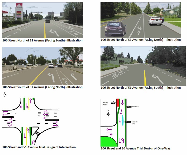
Trial modifications of 106 St and 109 St are being implemented as part of the Pleasantview Community Traffic Management Plan. The key changes for 106 St, which has an on-street bike lane, are:

  • North/south motor vehicle traffic is no longer allowed to travel straight through the intersection at 106 Street and 51 Avenue. Bicycle traffic is still able to travel straight through the intersection.
  • 106 Street between 53 Avenue and 56 Avenue is now one-way northbound for motor vehicles, with an additional northbound parking lane. Bicycle traffic is still able to travel north and south.

You can view the full details of the plan here.

pleasantview illustrations

Ward 10 Councillor Michael Walters has also written a blog post about the changes.

This is a trial, and may or may not be kept or modified at the end of the trial period. You can send your feedback to the City of Edmonton [email protected].

We are also interested in your thoughts from a cycling perspective. You can leave a comment here, via Twitter, or e-mail us.

102 Avenue protected bike lane from 99 St to 107 St

station-overhead.png

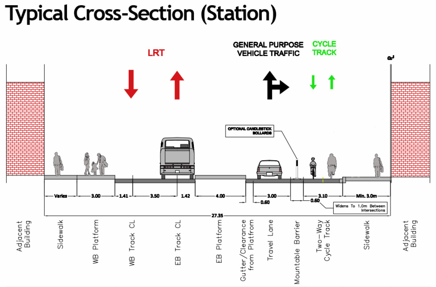
The City of Edmonton has just announced the new redesign for a protected, physically separated bike lane (also known as a cycle track) along 102 Ave downtown, in the same corridor as the Valley Line LRT.

The road safety review proposes a redesigned corridor that maintains the important multi-modal nature of 102 Avenue and increase safety for all road users. The proposed concept plan includes:

  • A South-side two-way cycle track
  • A North-side two-way LRT
  • A centre-running one-way motor vehicle travel
  • Sidewalks on both sides

You can read more about the plan, and view cross-sections and the concept plan, on the City's website.

102 Avenue cross section station

Total Closure, Groat Road from 107 Ave to River Valley Road

Please be advised that from 10 p.m. to 11 p.m. on Thursday July 23, Groat Road will be completely closed from 107 Avenue to River Valley Road for work on the 102 Avenue Bridge project. The shared-use path along the west side of Groat Road will also be closed from north of Government House Park to south of 107 Avenue.

Please see detour map here: http://www.edmonton.ca/transportation/roads_traffic/102-ave-over-groat-rd-closures-detours.aspx

Groat Bridge and Victoria Park Road will remain open during this time.

The City of Edmonton thanks residents for their patience while we carry out this road work.

Community Garden Bike Tours 2015

SFE-logo1.jpg

The 4th year of Sustainable Food Edmonton & Edmonton Bicycle Commuters community garden bicycle tours are here! Discover the people power and plants production in some community gardens in Edmonton. Each garden will have a host to share the stories of their garden – how the garden operates, how it came to be, and its impact on the local community.

Each tour will visit a different route with approximately 12-14 kms of leisurely riding. You must be comfortable with on-road cycling (light traffic only). Experienced cyclists will lead and tail.

Please bring your own:

  • well-maintained bicycle
  • helmet (mandatory for under 18; recommended for 18+)
  • bike lock
  • appropriate clothing (tour runs rain or shine!)
  • sun protection & bug protection
  • water, lunch & snack
  • optional: cash for the farmers market

Registration is FREE but required and you will be asked to sign a waiver and photo permission form before participating.

Register at: http://sustainablefoodedmonton.org/bike-tour-registration-2015/

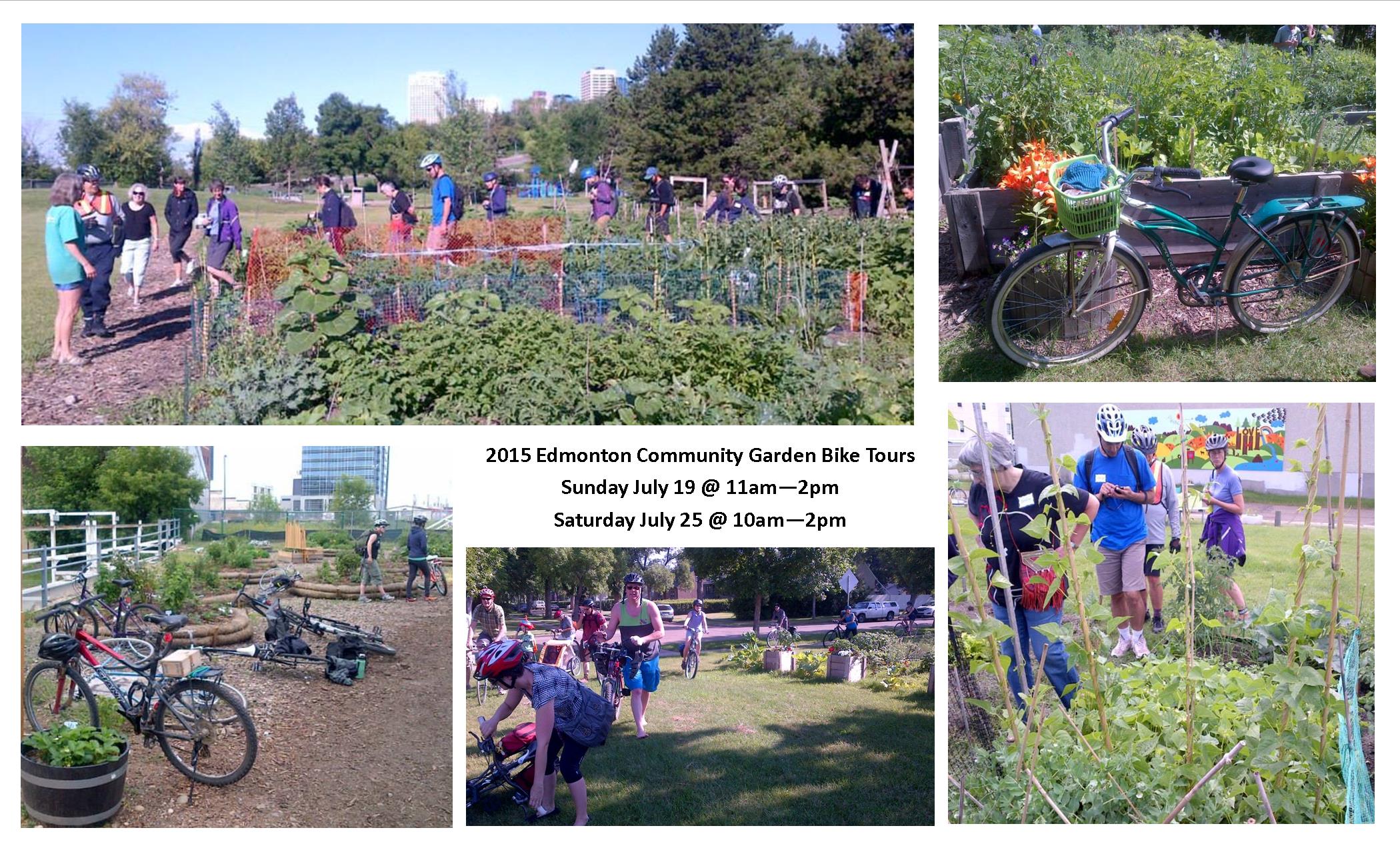
2015 community garden bike tours promo pics

Sunday July 19, 2015 11 am – 2 pm

Optional 10am: Meet at Culina Cafe in the Muttart Conservatory for brunch at the Garden Bike Tour table (at your own cost)

Meet at Muttart Conservatory (north end of parking lot by the pedestrian bridge), 9626 96A Street

Tour route map https://goo.gl/ySpzlM (subject to change) with the following stops:

  • Yellowhead Youth Centre Plant-A-Row, Grow-A-Row Garden
  • Cloverdale Community Garden
  • Mount Carmel Church Community Garden
  • Fulton Place "Sunshine" Community Garden
  • King's University Garden
  • Campus St. Jean Jardin Communautaire
  • Ending at the French Quarters Farmers Market (cash or debit)

Registration: http://sustainablefoodedmonton.org/bike-tour-registration-2015/

Saturday July 25, 2015 10 am – 2 pm

Meet at Century Park LRT/Bus Station (walk south along 111st and we'll be on the grass in front of Starbucks Coffee), 2397 111 Street

If you want to arrive via LRT or bus, here is the easy way to bring your bike on transit: http://www.edmonton.ca/transportation/ets/riding_ets/bikes-on-ets.aspx

Tour route map https://goo.gl/iTE92I (subject to change) with the following stops:

  • Yellowbird East Community Garden
  • Heritage Community Garden
  • Duggan Community Garden
  • Holy Spirit Church Garden
  • Michener Park Garden
  • Edmonton Organic Growers Guild
  • Prairie Urban Farm
  • Ending at the Green & Gold Garden Market (cash only)
  • Optional: Take LRT from South Campus station back to Century Park station. SFE will cover the cost of this fare!

Registration is FREE but mandatory at: http://sustainablefoodedmonton.org/bike-tour-registration-2015/


Where do people ride? Two maps

neighbourhood.png

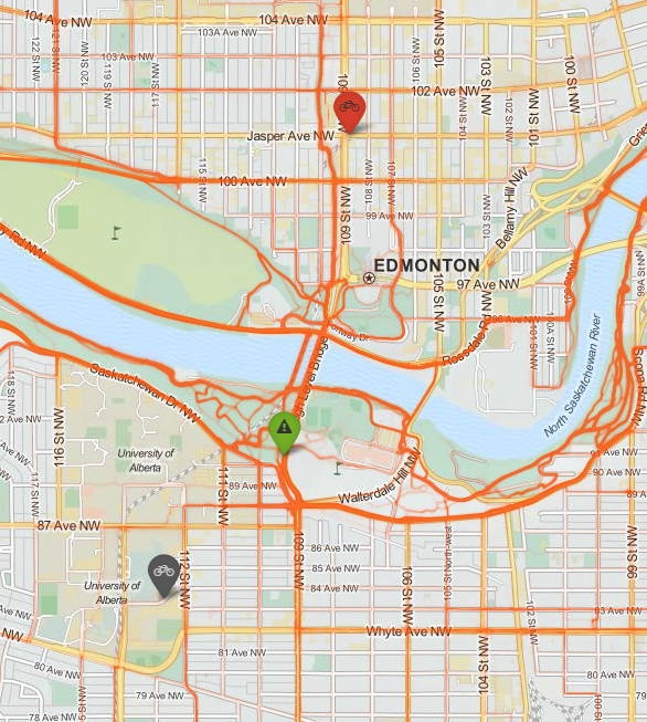
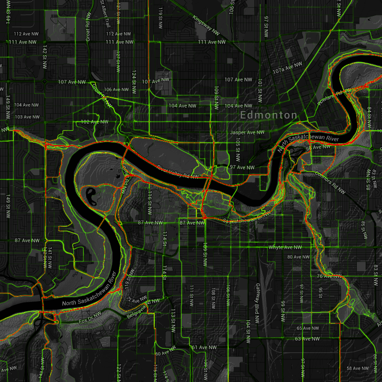
Here are two maps showing where people ride in Edmonton. The first is an interactive heatmap generated by Strava, a smartphone app. Strava compiles the maps using GPS data from app users who record their rides. As such, as a data source, it has limitations (the record is skewed towards the type of person that is more likely to record their rides using a smartphone app), but is still informative and very interesting:

Strava heat map

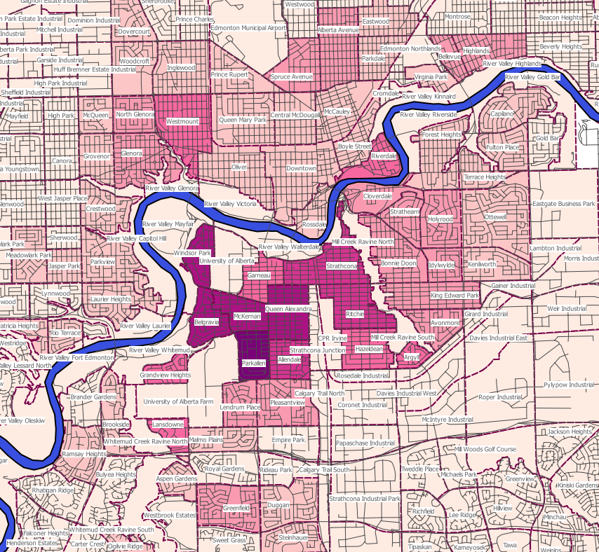
The second is a map we compiled using City of Edmonton 2014 census data. This data also has significant limitations, namely, the question asked is "Main Mode of Transportation from Home to Work". For many people, if they primarily bike for 5 months of the year, and then drive for 7 months, their answer will appear as "100% driver, 0% bicycle". Similarly for people who bike 2 days a week and drive 3 days: their cycling trips aren't represented at all in this data.

Additionally, most trips by bike are not for work (in the US, only about 13% of bike trips are for work), but our transportation network should still be accessible to everyone, regardless of the purpose of the trip. So census numbers greatly under-represent cycling. Still, they do offer a baseline for comparison between neighbourhoods.

Neighbourhood mode share

Saskatchewan Drive shared-use path closed

IMG_20150622_162050.jpg

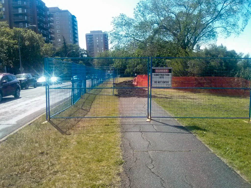
The shared-use path along Saskatchewan Drive between 105 St and 106 St is closed as part of work to improve access to Queen Elizabeth Park. Construction is expected to last about 2 weeks.

Pedestrians can detour by crossing at 105 St or 106 St and using the sidewalk on the south side of the road. Eastbound cyclists can ride on the roadway (either to the right or the left side). Westbound cyclists should dismount and walk as a pedestrian, or avoid using this section of Saskatchewan Drive.

As of the time of this posting, there was no signage at the pedestrian crossing points warning of a trail closure, and no night time-visible signage warning of the barriers on the trail. EBC has been in contact with the City Project Officer and they will be investigating on Tuesday. If signage and barrier warnings are still inadequate by Tuesday afternoon, please contact us.

Last year, the City of Edmonton closed the High Level Bridge with similar lack of regard for accessibility or the safety of users, leading to several hospitalizations.

Saskatchewan Drive closureSaskatchewan Drive closure

127 Street Collector Plan Open House on Wednesday

127 Street from Stony Plain Road to 118 Avenue is a project of the City’s Collector Concept Planning program. These projects are areas identified through the Neighbourhood Renewal public involvement process that would benefit from further in-depth public engagement and analysis. The project team will present the three concept plan options for 127 Street that have incorporated feedback from recent community Kitchen Table meetings and from the online discussion forum.

Date: Wednesday, June 17, 2015 Location: Inglewood Community League Hall Address: 12515 116 Avenue Time: 4:30-8:30pm Formal presentations at 5pm and 7pm

This meeting will provide an opportunity for the public to learn more about the project and to provide feedback on the concept plan options. In addition to presentations, information boards will outline the details of the designs and project staff will be available to answer questions. Come see the concept plan options and tell us what you think.

A concept plan is being developed for 127 Street in advance of Neighbourhood Renewal in Westmount in 2017 and in Inglewood, planned for 2019–2022.

127 Street through these two neighbourhoods is a one-way northbound collector road with parking on the east side and a contraflow bike lane on the other. Northbound cyclists share the travel lane with motor vehicle traffic. This roadway has been a bike route for 30 years and is well used by residents to access destinations within the neighbourhoods including parks, schools and businesses along 124 Street.

Although 127 Street was not identified in the Bicycle Transportation Plan, as part of the City’s Major Bike Grid, its connectivity across Yellowhead Trail makes it a desirable route for further development as a major bicycle facility, providing Edmontonians a greater range of travel mode choices for all ages and abilities.

Major downtown road closures Tuesday and Wednesday

EPSMemorial_TrafficDisruptionMap-V4.png

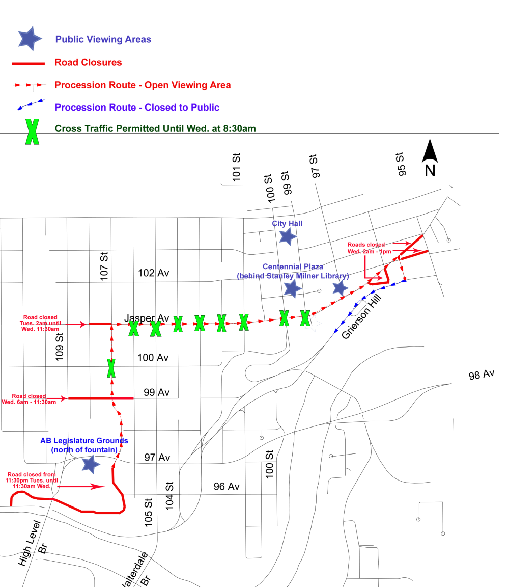
The Edmonton Police Service will honour the service and sacrifice of Constable Daniel Woodall, who was recently killed in the line of duty, with a regimental funeral and celebration of his life. There will be major traffic disruptions and parking restrictions downtown starting at 11:30pm on June 16 and continuing through June 17.

Please plan your route ahead to avoid being unable to traverse downtown. Full details can be found on the City's website.

The procession starts at the Alberta Legislature Building at 107 Street and 97 Avenue, proceeds northbound along 107 Street to Jasper Avenue, travels eastbound on Jasper Avenue to 95 Street, and then moves down Grierson Hill to the Shaw Conference Centre.

EPSMemorial_TrafficDisruptionMap-V4

Tues, June 16 at 11:30pm

  • 107 St, between 96 Ave - Jasper Ave
  • East-West cross traffic on 99 and 100 Ave will remain open

Wed, June 17 at 2am

  • Jasper Ave, between 95 - 108 St
  • North-South cross traffic on 99-106 St will remain open until 8:30am
  • 95A St, between Grierson Hill - Jasper Ave
  • 101 Ave, between 96 St - Jasper Ave
  • 96 St, between 101 Ave - Jasper Ave
  • 97 St, north of Jasper Ave
  • 101A Ave, east of 95A St
  • 100A St, north of Jasper Ave

Wed, June 17 at 6am

  • 99 Ave, between 106 - 109 St

Wed, June 17 at 8:30am

  • All cross traffic on procession route closed
  • Grierson Hill
  • 101 Ave, between 95 St - Grierson Hill

Roads will reopen at approximately 11:30am, starting on the west side of the procession route, with these two exceptions:

  • Jasper Avenue, 95 - 99 St will remain closed until approximately 1pm
  • Grierson Hill will remain closed until approximately 3:30pm

Share your Bike to the Symphony photos and videos

11378671_867927659928033_2130513409_n.jpg

Thanks to the 100+ riders that came out last night to Bike to the Symphony. Would you like to share your photos and videos from Bike to the Symphony with EBC and the ESO, so we can make a fantastic video and photo gallery?

Upload them here!

You Can Ride 2: Thank Yous

Rotary-Club-of-Spruce-Grove-flag-2.png

In March, members of the Rotary Club of Spruce Grove volunteered with You Can Ride 2 at one of our bike fitting days, experiencing the excitement and wonder that biking brings to families of children with special needs. They were in awe at the volunteerism that was completed to keep the program running. Barry Twynam, Community Services Director of the Rotary Club of Spruce Grove, identified that YCR2 could benefit from more exposure and funding. The Club chose YCR2 to be the beneficiary of the live auction portion of their annual Lobsterfest fundraiser. The live auction was a new event, so we were unsure how much would be raised. Barry and his daughter Devan Twynam put together a compelling video for the evening of the fundraiser.

On the night of the fundraiser, Janine Halayko, Melanie Harris, Trent Magis, the core volunteers that have driven YCR2 from the beginning and have been key to its success, took the stage and answered questions before the floor opened for bidding. In about 7 minutes, $90,000 was raised!

Thanks so much to the Rotary Club of Spruce Grove and the amazing generosity of the community members who were at the fundraiser that night. Spruce Grove is not a big city but they obviously can do very big things!

Thank you also to Inclusion Alberta (formerly Alberta Association for Community Living) for helping to make this fundraiser for YCR2 possible.

Additional Supporters

We would also like to recognize and thank these additional sponsors of YCR2:

Over 40 pediatric physiotherapists, occupational therapists and adapted phys ed consultants have also volunteered with the program this year.

Other generous financial donors also include:

Product donations/transportation

Storage/venue assistance

Service donations

Volunteer orientation

Are you interested in volunteering for EBC at either of our BikeWorks locations? As a volunteer, you can:

  • Learn bike repair, even if you start out knowing nothing (there are also many opportunities for non-mechanical volunteers)
  • Help people to enjoy fixing and riding bikes
  • Meet an amazing group of bike-loving volunteers and patrons
  • Access free, private classes for volunteers
  • Get discounts on parts and bikes
  • Get extra off-hours access to the shop
  • Get access to paid opportunities and job references
  • Join in group rides and social events

Whether you want to help out at BikeWorks North or South, please sign up to our upcoming volunteer orientation on the evening of June 16.

EBC Charitable status open house

On June 16, from 6:30pm-8pm at the atrium of La Cité francophone (8627 91 St), EBC will be hosting an open house for EBC members to discuss the potential for pursuing charitable registration. A presentation will be given by a member of the Board of Directors followed by questions and discussion. Please attend if you are interested in the development or have experience with transitions from not-for-profit to charity!

View the Charitable Status open house presentation (2015).

View a Summary of Research about EBC and Charitable Status (2014)

Have feedback or comments? Please share them with the Board of Directors by emailing [email protected].